Auckland geodata
Auckland is a seat of a first-order administrative division; located in New Zealand in Pacific/Auckland (GMT+12) time zone. With population of 417,910 people, there are 0 cities with bigger population in this country. Compared to other cities in New Zealand, 85.5% of cities are located further ↓South; 56.5% of cities are located further ←West and 57% of cities have lower elevation than Auckland. Note1


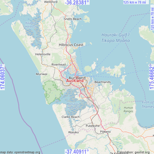
Auckland GPS coordinates[2]
36° 50' 54.708" South, 174° 45' 48.564" East
| Map corner | latitude | longitude |
|---|---|---|
| Upper-left | -36.28381°, | 174.06037° |
| Center: | -36.84853°, | 174.76349° |
| Lower-right: | -37.40911°, | 175.46662° |
| Map W x H: | 125.1×125.1 km | = 77.7×77.7mi |
| max Lat: | -34.99604° ⇑14.5% North |
| Auckland: | -36.84853° |
| min Lat: | ⇓85.5% South -46.6° |
| min Long | Auckland | max Long |
| -176.55973° | 174.76349° | 178.33333° |
| W 56.5%⇐ | ⇒43.5% E |
Elevation
Elevation of Auckland is 43 m = 141 ft, and this is 41.4 m = 136 ft below average elevation for this country.
| Max E: |
819 m = 2687 ft | 43% |
| Avg. | 84.4 m = 277 ft | |
| Auckland | 43 m = 141 ft | |
Min E: |
3 m = 10 ft | 57% |
See also: Auckland elevation on elevation.city.
Geographical zone
Auckland is located in South temperate zone (between Tropic of Capricorn and the Antarctic Circle). Distance of this Southern Tropic circle is 1491.3 km =926.7 mi to North.| Distance of | km | miles | from Auckland |
|---|---|---|---|
| Equator | 4097.2 | 2545.9 | to North |
| Tropic Capricorn | 1491.3 | 926.7 | to North |
| Antarctic Circle | 3304 | 2053 | to South |
| South Pole | 5909.9 | 3672.2 | to South |


Nearby cities:
15 places around Auckland: (largest is in red/bold)
• East Tamaki
16.6 km =10.3 mi,  132°
132°
• Mangere
13.7 km =8.5 mi,  166°
166°
• Manukau City
19.1 km =11.9 mi,  147°
147°
• Muriwai Beach
28.1 km =17.5 mi,  277°
277°
• Murrays Bay
13.4 km =8.3 mi,  354°
354°
• North Shore
5.5 km =3.4 mi, 347°
• Pakuranga
14.2 km =8.8 mi,  105°
105°
• Papakura
29 km =18 mi, 146°
• Rosebank
8.8 km =5.5 mi,  250°
250°
• Rothesay Bay
13.8 km =8.6 mi, 351°
• Takanini
25.3 km =15.7 mi, 151°
• Tamaki
9.7 km =6 mi,  117°
117°
• Titirangi
13.8 km =8.6 mi,  224°
224°
• Waitakere
12.1 km =7.5 mi,  230°
230°
• Wiri
18.7 km =11.6 mi, 152°
Sources, notices
• [Note1] Compared only with cities in New Zealand existing in our database
• [Src1] Map data: © OpenStreetMap contributors (CC-BY-SA)
• [Src2] Other city data from geonames.org with taken over terms of usage.
• [Src3] Geographical zone / Annual Mean Temperature by Robert A. Rohde @ Wikipedia
