Hanmer Springs geodata
Hanmer Springs (Canterbury) is a populated place; located in New Zealand in Pacific/Auckland (GMT+13) time zone. With population of 784 people, there are 158 cities with bigger population in this country. Compared to other cities in New Zealand, 72.9% of cities are located further ↑North; 70.5% of cities are located further →East and 96.6% of cities have lower elevation than Hanmer Springs. Note1


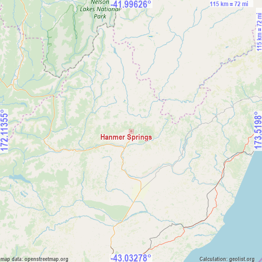
Hanmer Springs GPS coordinates[2]
42° 31' 0.012" South, 172° 49' 0.012" East
| Map corner | latitude | longitude |
|---|---|---|
| Upper-left | -41.99626°, | 172.11355° |
| Center: | -42.51667°, | 172.81667° |
| Lower-right: | -43.03278°, | 173.5198° |
| Map W x H: | 115.3×115.2 km | = 71.6×71.6mi |
| max Lat: | -34.99604° ⇑72.9% North |
| Hanmer Springs: | -42.51667° |
| min Lat: | ⇓27.1% South -46.6° |
| min Long | Hanmer Springs | max Long |
| -176.55973° | 172.81667° | 178.33333° |
| W 29.5%⇐ | ⇒70.5% E |
Elevation
Elevation of Hanmer Springs is 391 m = 1283 ft, and this is 306.6 m = 1006 ft above average elevation for this country.
| Max E: |
819 m = 2687 ft | 3.4% |
| Hanmer Springs | 391 m 1283 ft | |
| Avg. | 84.4 m = 277 ft | |
Min E: |
3 m = 10 ft | 96.6% |
See also: New Zealand elevation on elevation.city.
Geographical zone
Hanmer Springs is located in South temperate zone (between Tropic of Capricorn and the Antarctic Circle). Distance of this Southern Tropic circle is 2121.5 km =1318.2 mi to North.| Distance of | km | miles | from Hanmer Springs |
|---|---|---|---|
| Equator | 4727.4 | 2937.5 | to North |
| Tropic Capricorn | 2121.5 | 1318.2 | to North |
| Antarctic Circle | 2673.8 | 1661.4 | to South |
| South Pole | 5279.7 | 3280.7 | to South |


Nearby cities:
15 places around Hanmer Springs: (largest is in red/bold)
• Amberley
71.4 km =44.4 mi,  185°
185°
• Arthur’s Pass
112.9 km =70.2 mi,  244°
244°
• Christchurch
114 km =70.8 mi, 187°
• Darfield
121.6 km =75.6 mi,  207°
207°
• Gloriavale Christian Church
91.7 km =57 mi,  263°
263°
• Kaiapoi
96.9 km =60.2 mi, 188°
• Kaikoura
71.9 km =44.7 mi,  81°
81°
• Murchison
89.1 km =55.4 mi,  333°
333°
• Oxford
101.2 km =62.9 mi, 210°
• Prebbleton
121.1 km =75.2 mi, 191°
• Reefton
89.9 km =55.9 mi,  299°
299°
• Rolleston
123.7 km =76.9 mi,  196°
196°
• Sefton
82.4 km =51.2 mi, 188°
• Waikuku
87.8 km =54.6 mi, 187°
• Woodend
89.8 km =55.8 mi, 187°
Sources, notices
• [Note1] Compared only with cities in New Zealand existing in our database
• [Src1] Map data: © OpenStreetMap contributors (CC-BY-SA)
• [Src2] Other city data from geonames.org with taken over terms of usage.
• [Src3] Geographical zone / Annual Mean Temperature by Robert A. Rohde @ Wikipedia
