Bulls geodata
Bulls (Manawatu-Wanganui) is a populated place; located in New Zealand in Pacific/Auckland (GMT+12) time zone. With population of 1,781 people, there are 107 cities with bigger population in this country. Compared to other cities in New Zealand, 52.2% of cities are located further ↑North; 73.4% of cities are located further ←West and 62.8% of cities have lower elevation than Bulls. Note1


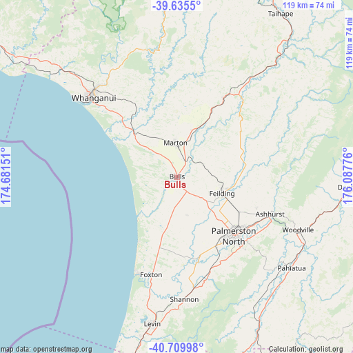
Bulls GPS coordinates[2]
40° 10' 29.532" South, 175° 23' 4.668" East
| Map corner | latitude | longitude |
|---|---|---|
| Upper-left | -39.6355°, | 174.68151° |
| Center: | -40.17487°, | 175.38463° |
| Lower-right: | -40.70998°, | 176.08776° |
| Map W x H: | 119.5×119.5 km | = 74.3×74.3mi |
| max Lat: | -34.99604° ⇑52.2% North |
| Bulls: | -40.17487° |
| min Lat: | ⇓47.8% South -46.6° |
| min Long | Bulls | max Long |
| -176.55973° | 175.38463° | 178.33333° |
| W 73.4%⇐ | ⇒26.6% E |
Elevation
Elevation of Bulls is 55 m = 180 ft, and this is 29.4 m = 96 ft below average elevation for this country.
| Max E: |
819 m = 2687 ft | 37.2% |
| Avg. | 84.4 m = 277 ft | |
| Bulls | 55 m = 180 ft | |
Min E: |
3 m = 10 ft | 62.8% |
See also: New Zealand elevation on elevation.city.
Geographical zone
Bulls is located in South temperate zone (between Tropic of Capricorn and the Antarctic Circle). Distance of this Southern Tropic circle is 1861.1 km =1156.4 mi to North.| Distance of | km | miles | from Bulls |
|---|---|---|---|
| Equator | 4467 | 2775.7 | to North |
| Tropic Capricorn | 1861.1 | 1156.4 | to North |
| Antarctic Circle | 2934.1 | 1823.2 | to South |
| South Pole | 5540 | 3442.4 | to South |


Nearby cities:
15 places around Bulls: (largest is in red/bold)
• Foxton
33.2 km =20.6 mi,  192°
192°
• Himatangi
25.7 km =16 mi, 192°
• Hunterville
30.8 km =19.1 mi,  30°
30°
• Levin
51.8 km =32.2 mi, 190°
• Linton Military Camp
30.4 km =18.9 mi,  146°
146°
• Manakau
61.9 km =38.5 mi, 193°
• Otaki
67.8 km =42.1 mi,  197°
197°
• Palmerston North
27.9 km =17.3 mi,  136°
136°
• Rongotea
13.5 km =8.4 mi,  165°
165°
• Sanson
6.1 km =3.8 mi, 146°
• Te Horo
73.6 km =45.7 mi, 199°
• Tokomaru
34.8 km =21.6 mi,  162°
162°
• Waiouru
81.2 km =50.5 mi,  17°
17°
• Wanganui
39.1 km =24.3 mi,  313°
313°
• Waverley
78.5 km =48.8 mi, 305°
Sources, notices
• [Note1] Compared only with cities in New Zealand existing in our database
• [Src1] Map data: © OpenStreetMap contributors (CC-BY-SA)
• [Src2] Other city data from geonames.org with taken over terms of usage.
• [Src3] Geographical zone / Annual Mean Temperature by Robert A. Rohde @ Wikipedia
