Wanganui geodata
Wanganui (Manawatu-Wanganui) is a populated place; located in New Zealand in Pacific/Auckland (GMT+12) time zone. With population of 40,268 people, there are 20 cities with bigger population in this country. Compared to other cities in New Zealand, 50.7% of cities are located further ↑North; 67.6% of cities are located further ←West and 67.6% of cities have higher elevation than Wanganui. Note1


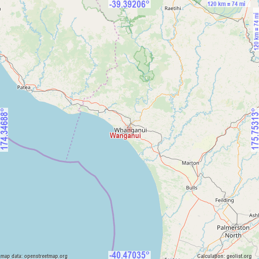
Wanganui GPS coordinates[2]
39° 55' 59.988" South, 175° 3' 0" East
| Map corner | latitude | longitude |
|---|---|---|
| Upper-left | -39.39206°, | 174.34688° |
| Center: | -39.93333°, | 175.05° |
| Lower-right: | -40.47035°, | 175.75313° |
| Map W x H: | 119.9×119.9 km | = 74.5×74.5mi |
| max Lat: | -34.99604° ⇑50.7% North |
| Wanganui: | -39.93333° |
| min Lat: | ⇓49.3% South -46.6° |
| min Long | Wanganui | max Long |
| -176.55973° | 175.05° | 178.33333° |
| W 67.6%⇐ | ⇒32.4% E |
Elevation
Elevation of Wanganui is 18 m = 59 ft, and this is 66.4 m = 218 ft below average elevation for this country.
| Max E: |
819 m = 2687 ft | 67.6% |
| Avg. | 84.4 m = 277 ft | |
| Wanganui | 18 m = 59 ft | |
Min E: |
3 m = 10 ft | 32.4% |
See also: Wanganui elevation on elevation.city.
Geographical zone
Wanganui is located in South temperate zone (between Tropic of Capricorn and the Antarctic Circle). Distance of this Southern Tropic circle is 1834.3 km =1139.8 mi to North.| Distance of | km | miles | from Wanganui |
|---|---|---|---|
| Equator | 4440.2 | 2759 | to North |
| Tropic Capricorn | 1834.3 | 1139.8 | to North |
| Antarctic Circle | 2961 | 1839.9 | to South |
| South Pole | 5566.9 | 3459.1 | to South |


Nearby cities:
15 places around Wanganui: (largest is in red/bold)
• Bulls
39.1 km =24.3 mi,  133°
133°
• Eltham
85.2 km =52.9 mi,  311°
311°
• Foxton
63 km =39.1 mi,  160°
160°
• Hawera
75.7 km =47 mi,  300°
300°
• Himatangi
56.6 km =35.2 mi, 156°
• Hunterville
44.2 km =27.5 mi,  90°
90°
• Levin
80.1 km =49.8 mi,  166°
166°
• Linton Military Camp
69.1 km =42.9 mi,  139°
139°
• Palmerston North
67 km =41.6 mi, 134°
• Patea
52.1 km =32.4 mi,  291°
291°
• Rongotea
51.1 km =31.8 mi, 141°
• Sanson
45.1 km =28 mi, 135°
• Tokomaru
71.6 km =44.5 mi,  146°
146°
• Waiouru
73.3 km =45.5 mi,  46°
46°
• Waverley
40.1 km =24.9 mi, 297°
Sources, notices
• [Note1] Compared only with cities in New Zealand existing in our database
• [Src1] Map data: © OpenStreetMap contributors (CC-BY-SA)
• [Src2] Other city data from geonames.org with taken over terms of usage.
• [Src3] Geographical zone / Annual Mean Temperature by Robert A. Rohde @ Wikipedia
