Ngaruawahia geodata
Ngaruawahia (Waikato) is a populated place; located in New Zealand in Pacific/Auckland (GMT+13) time zone. With population of 5,106 people, there are 57 cities with bigger population in this country. Compared to other cities in New Zealand, 72% of cities are located further ↓South; 70% of cities are located further ←West and 67.6% of cities have higher elevation than Ngaruawahia. Note1


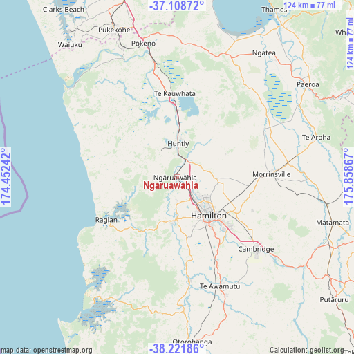
Ngaruawahia GPS coordinates[2]
37° 40' 2.568" South, 175° 9' 19.944" East
| Map corner | latitude | longitude |
|---|---|---|
| Upper-left | -37.10872°, | 174.45242° |
| Center: | -37.66738°, | 175.15554° |
| Lower-right: | -38.22186°, | 175.85867° |
| Map W x H: | 123.8×123.8 km | = 76.9×76.9mi |
| max Lat: | -34.99604° ⇑28% North |
| Ngaruawahia: | -37.66738° |
| min Lat: | ⇓72% South -46.6° |
| min Long | Ngaruawahia | max Long |
| -176.55973° | 175.15554° | 178.33333° |
| W 70%⇐ | ⇒30% E |
Elevation
Elevation of Ngaruawahia is 18 m = 59 ft, and this is 66.4 m = 218 ft below average elevation for this country.
| Max E: |
819 m = 2687 ft | 67.6% |
| Avg. | 84.4 m = 277 ft | |
| Ngaruawahia | 18 m = 59 ft | |
Min E: |
3 m = 10 ft | 32.4% |
See also: New Zealand elevation on elevation.city.
Geographical zone
Ngaruawahia is located in South temperate zone (between Tropic of Capricorn and the Antarctic Circle). Distance of this Southern Tropic circle is 1582.3 km =983.2 mi to North.| Distance of | km | miles | from Ngaruawahia |
|---|---|---|---|
| Equator | 4188.2 | 2602.4 | to North |
| Tropic Capricorn | 1582.3 | 983.2 | to North |
| Antarctic Circle | 3213 | 1996.5 | to South |
| South Pole | 5818.8 | 3615.6 | to South |


Nearby cities:
15 places around Ngaruawahia: (largest is in red/bold)
• Bombay
57.7 km =35.9 mi,  344°
344°
• Cambridge
34.3 km =21.3 mi,  133°
133°
• Hamilton
17.1 km =10.6 mi,  138°
138°
• Kawhia
53.4 km =33.2 mi,  213°
213°
• Kerepehi
52.7 km =32.7 mi,  39°
39°
• Matamata
55.7 km =34.6 mi,  106°
106°
• Ngatea
52.4 km =32.6 mi, 35°
• Otorohanga
57.5 km =35.7 mi,  176°
176°
• Paeroa
56.1 km =34.9 mi,  53°
53°
• Pukekohe East
55 km =34.2 mi, 340°
• Raglan
28.1 km =17.5 mi,  238°
238°
• Te Kauwhata
29.7 km =18.5 mi,  359°
359°
• Tirau
62.9 km =39.1 mi,  123°
123°
• Waharoa
54.9 km =34.1 mi,  101°
101°
• Waiuku
59.6 km =37 mi,  321°
321°
Sources, notices
• [Note1] Compared only with cities in New Zealand existing in our database
• [Src1] Map data: © OpenStreetMap contributors (CC-BY-SA)
• [Src2] Other city data from geonames.org with taken over terms of usage.
• [Src3] Geographical zone / Annual Mean Temperature by Robert A. Rohde @ Wikipedia
