Matamata geodata
Matamata (Waikato) is a populated place; located in New Zealand in Pacific/Auckland (GMT+13) time zone. With population of 6,306 people, there are 53 cities with bigger population in this country. Compared to other cities in New Zealand, 69.1% of cities are located further ↓South; 82.1% of cities are located further ←West and 69.1% of cities have lower elevation than Matamata. Note1


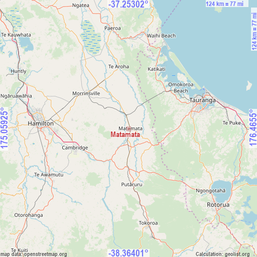
Matamata GPS coordinates[2]
37° 48' 38.16" South, 175° 45' 44.532" East
| Map corner | latitude | longitude |
|---|---|---|
| Upper-left | -37.25302°, | 175.05925° |
| Center: | -37.8106°, | 175.76237° |
| Lower-right: | -38.36401°, | 176.4655° |
| Map W x H: | 123.5×123.5 km | = 76.7×76.7mi |
| max Lat: | -34.99604° ⇑30.9% North |
| Matamata: | -37.8106° |
| min Lat: | ⇓69.1% South -46.6° |
| min Long | Matamata | max Long |
| -176.55973° | 175.76237° | 178.33333° |
| W 82.1%⇐ | ⇒17.9% E |
Elevation
Elevation of Matamata is 67 m = 220 ft, and this is 17.4 m = 57 ft below average elevation for this country.
| Max E: |
819 m = 2687 ft | 30.9% |
| Avg. | 84.4 m = 277 ft | |
| Matamata | 67 m = 220 ft | |
Min E: |
3 m = 10 ft | 69.1% |
See also: New Zealand elevation on elevation.city.
Geographical zone
Matamata is located in South temperate zone (between Tropic of Capricorn and the Antarctic Circle). Distance of this Southern Tropic circle is 1598.2 km =993.1 mi to North.| Distance of | km | miles | from Matamata |
|---|---|---|---|
| Equator | 4204.1 | 2612.3 | to North |
| Tropic Capricorn | 1598.2 | 993.1 | to North |
| Antarctic Circle | 3197 | 1986.5 | to South |
| South Pole | 5802.9 | 3605.8 | to South |


Nearby cities:
15 places around Matamata: (largest is in red/bold)
• Athenree
40.6 km =25.2 mi,  19°
19°
• Cambridge
29.3 km =18.2 mi,  255°
255°
• Hamilton
42.2 km =26.2 mi,  274°
274°
• Katikati
32 km =19.9 mi,  25°
25°
• Mamaku
42.7 km =26.5 mi,  138°
138°
• Ngaruawahia
55.7 km =34.6 mi,  286°
286°
• Paengaroa
57.5 km =35.7 mi,  90°
90°
• Paeroa
50.1 km =31.1 mi,  350°
350°
• Rotorua
55.9 km =34.7 mi,  130°
130°
• Tauranga
38.1 km =23.7 mi,  68°
68°
• Tirau
19.2 km =11.9 mi,  183°
183°
• Tokoroa
47.9 km =29.8 mi,  169°
169°
• Waharoa
4.9 km =3 mi,  4°
4°
• Waihi
47.9 km =29.8 mi,  7°
7°
• Waihi Beach
48.1 km =29.9 mi, 18°
Sources, notices
• [Note1] Compared only with cities in New Zealand existing in our database
• [Src1] Map data: © OpenStreetMap contributors (CC-BY-SA)
• [Src2] Other city data from geonames.org with taken over terms of usage.
• [Src3] Geographical zone / Annual Mean Temperature by Robert A. Rohde @ Wikipedia
