Tambo geodata
Tambo (Coclé) is a populated place; located in Panama in America/Panama (GMT-5) time zone. With population of 607 people, there are 408 cities with bigger population in this country. Compared to other cities in Panama, 68.3% of cities are located further ↓South; 62.3% of cities are located further ←West and 74.1% of cities have lower elevation than Tambo. Note1


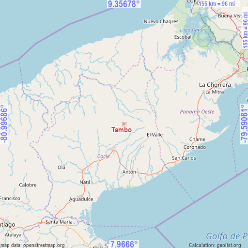
Tambo GPS coordinates[2]
8° 39' 44.388" North, 80° 17' 37.428" West
| Map corner | latitude | longitude |
|---|---|---|
| Upper-left | 9.35678°, | -80.99686° |
| Center: | 8.66233°, | -80.29373° |
| Lower-right: | 7.9666°, | -79.59061° |
| Map W x H: | 154.6×154.6 km | = 96.1×96.1mi |
| max Lat: | 9.60898° ⇑31.7% North |
| Tambo: | 8.66233° |
| min Lat: | ⇓68.3% South 7.26534° |
| min Long | Tambo | max Long |
| -82.91275° | -80.29373° | -77.38965° |
| W 62.3%⇐ | ⇒37.7% E |
Elevation
Elevation of Tambo is 190 m = 623 ft, and this is 17.9 m = 59 ft above average elevation for this country.
| Max E: |
2103 m = 6900 ft | 25.9% |
| Tambo | 190 m 623 ft | |
| Avg. | 172.1 m = 565 ft | |
Min E: |
-1 m = -3 ft | 74.1% |
See also: Panama elevation on elevation.city.
Geographical zone
Tambo is located in North Torrid zone (between Equator and Tropic of Cancer). Distance of Equator is 963.2 km =598.5 mi to South.| Distance of | km | miles | from Tambo |
|---|---|---|---|
| North Pole | 9043.9 | 5619.6 | to North |
| Arctic Circle | 6438 | 4000.4 | to North |
| Tropic Cancer | 1642.8 | 1020.8 | to North |
| Equator | 963.2 | 598.5 | to South |


Nearby cities:
15 places around Tambo: (largest is in red/bold)
• Caimito
7.4 km =4.6 mi,  126°
126°
• Chiguirí Arriba
11.5 km =7.1 mi,  84°
84°
• Churuquita Chiquita
10 km =6.2 mi,  165°
165°
• Churuquita Grande
7.9 km =4.9 mi,  162°
162°
• Las Minas
11.3 km =7 mi,  257°
257°
• Membrillo
12.6 km =7.8 mi,  135°
135°
• Miraflores
4.5 km =2.8 mi, 155°
• Pajonal Abajo
9.4 km =5.8 mi, 155°
• Rincón de Las Palmas
12.8 km =8 mi, 157°
• San Pedro
10.2 km =6.3 mi,  49°
49°
• Sofre
9.9 km =6.2 mi,  121°
121°
• Sonadora
12.9 km =8 mi,  196°
196°
• Toabré
3.2 km =2 mi,  247°
247°
• Turega
12.2 km =7.6 mi, 117°
• Vaquilla
11.4 km =7.1 mi,  71°
71°
Sources, notices
• [Note1] Compared only with cities in Panama existing in our database
• [Src1] Map data: © OpenStreetMap contributors (CC-BY-SA)
• [Src2] Other city data from geonames.org with taken over terms of usage.
• [Src3] Geographical zone / Annual Mean Temperature by Robert A. Rohde @ Wikipedia
