Turega geodata
Turega (Coclé) is a populated place; located in Panama in America/Panama (GMT-5) time zone. With population of 591 people, there are 416 cities with bigger population in this country. Compared to other cities in Panama, 64.4% of cities are located further ↓South; 67.8% of cities are located further ←West and 85.4% of cities have lower elevation than Turega. Note1


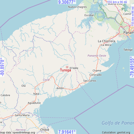
Turega GPS coordinates[2]
8° 36' 44.028" North, 80° 11' 40.812" West
| Map corner | latitude | longitude |
|---|---|---|
| Upper-left | 9.30677°, | -80.8978° |
| Center: | 8.61223°, | -80.19467° |
| Lower-right: | 7.91641°, | -79.49155° |
| Map W x H: | 154.6×154.6 km | = 96.1×96.1mi |
| max Lat: | 9.60898° ⇑35.6% North |
| Turega: | 8.61223° |
| min Lat: | ⇓64.4% South 7.26534° |
| min Long | Turega | max Long |
| -82.91275° | -80.19467° | -77.38965° |
| W 67.8%⇐ | ⇒32.2% E |
Elevation
Elevation of Turega is 341 m = 1119 ft, and this is 168.9 m = 554 ft above average elevation for this country.
| Max E: |
2103 m = 6900 ft | 14.6% |
| Turega | 341 m 1119 ft | |
| Avg. | 172.1 m = 565 ft | |
Min E: |
-1 m = -3 ft | 85.4% |
See also: Panama elevation on elevation.city.
Geographical zone
Turega is located in North Torrid zone (between Equator and Tropic of Cancer). Distance of Equator is 957.6 km =595 mi to South.| Distance of | km | miles | from Turega |
|---|---|---|---|
| North Pole | 9049.5 | 5623.1 | to North |
| Arctic Circle | 6443.6 | 4003.9 | to North |
| Tropic Cancer | 1648.3 | 1024.2 | to North |
| Equator | 957.6 | 595 | to South |


Nearby cities:
15 places around Turega: (largest is in red/bold)
• Alto de La Estancia
2.9 km =1.8 mi,  157°
157°
• Caballero
7.7 km =4.8 mi,  182°
182°
• Cabuya
7.8 km =4.8 mi, 157°
• Caimito
5 km =3.1 mi,  283°
283°
• Chiguirí Arriba
6.7 km =4.2 mi,  4°
4°
• Churuquita Grande
8.7 km =5.4 mi,  256°
256°
• Entradero
5 km =3.1 mi,  196°
196°
• Membrillo
3.9 km =2.4 mi,  210°
210°
• Miraflores
9.2 km =5.7 mi, 278°
• Pajonal Abajo
7.6 km =4.7 mi,  246°
246°
• Rincón de Las Palmas
8.8 km =5.5 mi,  223°
223°
• San Juan de Dios
7.6 km =4.7 mi, 207°
• Sofre
2.4 km =1.5 mi, 278°
• Tavidal Arriba
8.1 km =5 mi,  15°
15°
• Vaquilla
9.2 km =5.7 mi,  359°
359°
Sources, notices
• [Note1] Compared only with cities in Panama existing in our database
• [Src1] Map data: © OpenStreetMap contributors (CC-BY-SA)
• [Src2] Other city data from geonames.org with taken over terms of usage.
• [Src3] Geographical zone / Annual Mean Temperature by Robert A. Rohde @ Wikipedia
