San Juan del Tejal geodata
San Juan del Tejal (Chiriquí) is a populated place; located in Panama in America/Panama (GMT-5) time zone. With population of 641 people, there are 390 cities with bigger population in this country. Compared to other cities in Panama, 52.1% of cities are located further ↓South; 88% of cities are located further →East and 58.2% of cities have lower elevation than San Juan del Tejal. Note1


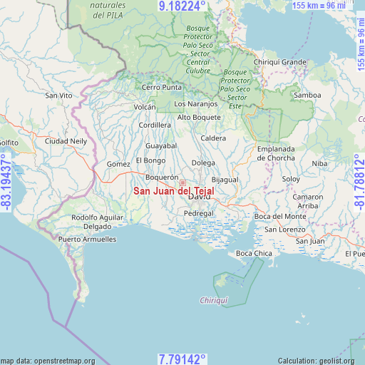
San Juan del Tejal GPS coordinates[2]
8° 29' 14.856" North, 82° 29' 28.464" West
| Map corner | latitude | longitude |
|---|---|---|
| Upper-left | 9.18224°, | -83.19437° |
| Center: | 8.48746°, | -82.49124° |
| Lower-right: | 7.79142°, | -81.78812° |
| Map W x H: | 154.6×154.6 km | = 96.1×96.1mi |
| max Lat: | 9.60898° ⇑47.9% North |
| San Juan del Tejal: | 8.48746° |
| min Lat: | ⇓52.1% South 7.26534° |
| min Long | San Juan del Te | max Long |
| -82.91275° | -82.49124° | -77.38965° |
| W 12%⇐ | ⇒88% E |
Elevation
Elevation of San Juan del Tejal is 97 m = 318 ft, and this is 75.1 m = 246 ft below average elevation for this country.
| Max E: |
2103 m = 6900 ft | 41.8% |
| Avg. | 172.1 m = 565 ft | |
| San Juan del Tejal | 97 m = 318 ft | |
Min E: |
-1 m = -3 ft | 58.2% |
See also: Panama elevation on elevation.city.
Geographical zone
San Juan del Tejal is located in North Torrid zone (between Equator and Tropic of Cancer). Distance of Equator is 943.7 km =586.4 mi to South.| Distance of | km | miles | from San Juan del Tejal |
|---|---|---|---|
| North Pole | 9063.3 | 5631.7 | to North |
| Arctic Circle | 6457.5 | 4012.5 | to North |
| Tropic Cancer | 1662.2 | 1032.8 | to North |
| Equator | 943.7 | 586.4 | to South |


Nearby cities:
15 places around San Juan del Tejal: (largest is in red/bold)
• Aguacatal
4.9 km =3 mi,  126°
126°
• Bágala
4.6 km =2.9 mi,  235°
235°
• Guaca Arriba
5.5 km =3.4 mi,  358°
358°
• Los Algarrobos
7.4 km =4.6 mi,  82°
82°
• Montilla
2.9 km =1.8 mi,  153°
153°
• Nuevo San Carlitos
6.8 km =4.2 mi,  119°
119°
• Portachuelo
8.1 km =5 mi,  101°
101°
• Pueblo Nuevo
5.1 km =3.2 mi,  343°
343°
• San Carlitos
4.5 km =2.8 mi,  94°
94°
• San Carlos
3.8 km =2.4 mi,  328°
328°
• San Pablo Nuevo Abajo
7 km =4.3 mi,  189°
189°
• San Pablo Viejo Abajo
4 km =2.5 mi,  197°
197°
• San Pablo Viejo Arriba
1.7 km =1.1 mi, 241°
• Tijeras
7.7 km =4.8 mi,  259°
259°
• Tinajas
8.1 km =5 mi,  25°
25°
Sources, notices
• [Note1] Compared only with cities in Panama existing in our database
• [Src1] Map data: © OpenStreetMap contributors (CC-BY-SA)
• [Src2] Other city data from geonames.org with taken over terms of usage.
• [Src3] Geographical zone / Annual Mean Temperature by Robert A. Rohde @ Wikipedia
