El Giral geodata
El Giral (Colón) is a populated place; located in Panama in America/Panama (GMT-5) time zone. With population of 1,522 people, there are 154 cities with bigger population in this country. Compared to other cities in Panama, 93.5% of cities are located further ↓South; 82.9% of cities are located further ←West and 59.4% of cities have lower elevation than El Giral. Note1


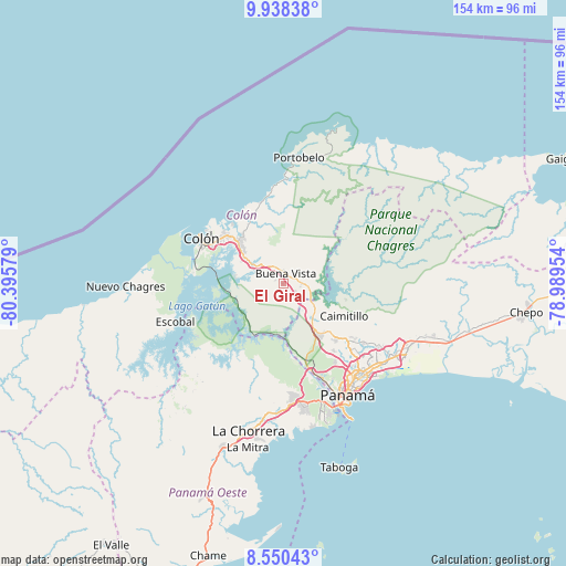
El Giral GPS coordinates[2]
9° 14' 42.324" North, 79° 41' 33.576" West
| Map corner | latitude | longitude |
|---|---|---|
| Upper-left | 9.93838°, | -80.39579° |
| Center: | 9.24509°, | -79.69266° |
| Lower-right: | 8.55043°, | -78.98954° |
| Map W x H: | 154.3×154.3 km | = 95.9×95.9mi |
| max Lat: | 9.60898° ⇑6.5% North |
| El Giral: | 9.24509° |
| min Lat: | ⇓93.5% South 7.26534° |
| min Long | El Giral | max Long |
| -82.91275° | -79.69266° | -77.38965° |
| W 82.9%⇐ | ⇒17.1% E |
Elevation
Elevation of El Giral is 102 m = 335 ft, and this is 70.1 m = 230 ft below average elevation for this country.
| Max E: |
2103 m = 6900 ft | 40.6% |
| Avg. | 172.1 m = 565 ft | |
| El Giral | 102 m = 335 ft | |
Min E: |
-1 m = -3 ft | 59.4% |
See also: Panama elevation on elevation.city.
Geographical zone
El Giral is located in North Torrid zone (between Equator and Tropic of Cancer). Distance of Equator is 1028 km =638.8 mi to South.| Distance of | km | miles | from El Giral |
|---|---|---|---|
| North Pole | 8979.1 | 5579.4 | to North |
| Arctic Circle | 6373.2 | 3960.1 | to North |
| Tropic Cancer | 1578 | 980.5 | to North |
| Equator | 1028 | 638.8 | to South |


Nearby cities:
15 places around El Giral: (largest is in red/bold)
• Buena Vista
3.2 km =2 mi,  354°
354°
• Chilibre
13.1 km =8.1 mi,  143°
143°
• El Valle de la Unión
3.7 km =2.3 mi,  105°
105°
• Gatuncillo
4.8 km =3 mi,  92°
92°
• Gatún
10 km =6.2 mi,  299°
299°
• Nueva Providencia
13.6 km =8.5 mi,  278°
278°
• Nuevo San Juan
3.9 km =2.4 mi,  131°
131°
• Nuevo Vigía
9.3 km =5.8 mi, 91°
• Palenque
4.5 km =2.8 mi,  163°
163°
• Quebrada Bonita Adentro
5.9 km =3.7 mi, 345°
• Río Duque
2 km =1.2 mi,  48°
48°
• Río Rita
12.7 km =7.9 mi, 300°
• Salamanca
14 km =8.7 mi,  44°
44°
• Sardinilla
8.3 km =5.2 mi, 44°
• Villa Unida
9.7 km =6 mi, 129°
Sources, notices
• [Note1] Compared only with cities in Panama existing in our database
• [Src1] Map data: © OpenStreetMap contributors (CC-BY-SA)
• [Src2] Other city data from geonames.org with taken over terms of usage.
• [Src3] Geographical zone / Annual Mean Temperature by Robert A. Rohde @ Wikipedia
