Rancho Café geodata
Rancho Café (Panamá) is a populated place; located in Panama in America/Panama (GMT-5) time zone. With population of 711 people, there are 350 cities with bigger population in this country. Compared to other cities in Panama, 88.2% of cities are located further ↓South; 88.9% of cities are located further ←West and 65.2% of cities have lower elevation than Rancho Café. Note1


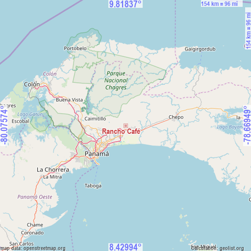
Rancho Café GPS coordinates[2]
9° 7' 29.388" North, 79° 22' 21.396" West
| Map corner | latitude | longitude |
|---|---|---|
| Upper-left | 9.81837°, | -80.07574° |
| Center: | 9.12483°, | -79.37261° |
| Lower-right: | 8.42994°, | -78.66949° |
| Map W x H: | 154.4×154.4 km | = 95.9×95.9mi |
| max Lat: | 9.60898° ⇑11.8% North |
| Rancho Café: | 9.12483° |
| min Lat: | ⇓88.2% South 7.26534° |
| min Long | Rancho Café | max Long |
| -82.91275° | -79.37261° | -77.38965° |
| W 88.9%⇐ | ⇒11.1% E |
Elevation
Elevation of Rancho Café is 126 m = 413 ft, and this is 46.1 m = 151 ft below average elevation for this country.
| Max E: |
2103 m = 6900 ft | 34.8% |
| Avg. | 172.1 m = 565 ft | |
| Rancho Café | 126 m = 413 ft | |
Min E: |
-1 m = -3 ft | 65.2% |
See also: Panama elevation on elevation.city.
Geographical zone
Rancho Café is located in North Torrid zone (between Equator and Tropic of Cancer). Distance of Equator is 1014.6 km =630.4 mi to South.| Distance of | km | miles | from Rancho Café |
|---|---|---|---|
| North Pole | 8992.5 | 5587.7 | to North |
| Arctic Circle | 6386.6 | 3968.4 | to North |
| Tropic Cancer | 1591.3 | 988.8 | to North |
| Equator | 1014.6 | 630.4 | to South |


Nearby cities:
15 places around Rancho Café: (largest is in red/bold)
• Cabra Número Uno
4.3 km =2.7 mi,  114°
114°
• Cerro Azul
6.4 km =4 mi,  304°
304°
• Juan Díaz
11.9 km =7.4 mi,  225°
225°
• Juan Gil
14.1 km =8.8 mi,  65°
65°
• La Colorada
5.4 km =3.4 mi,  242°
242°
• La Mesa
12.1 km =7.5 mi,  63°
63°
• Los Lotes
9.1 km =5.7 mi,  90°
90°
• Nueva Esperanza
4.9 km =3 mi,  120°
120°
• Nuevo Belén
5.6 km =3.5 mi,  206°
206°
• Pacora
10.4 km =6.5 mi, 119°
• Paso Blanco
14 km =8.7 mi, 88°
• Pedregal
9.3 km =5.8 mi, 225°
• San Miguelito
13.6 km =8.5 mi, 232°
• Tocumen
4.1 km =2.5 mi,  196°
196°
• Vista Hermosa
1.9 km =1.2 mi,  139°
139°
Sources, notices
• [Note1] Compared only with cities in Panama existing in our database
• [Src1] Map data: © OpenStreetMap contributors (CC-BY-SA)
• [Src2] Other city data from geonames.org with taken over terms of usage.
• [Src3] Geographical zone / Annual Mean Temperature by Robert A. Rohde @ Wikipedia
