Nuevo Belén geodata
Nuevo Belén (Panamá) is a section of populated place; located in Panama in America/Panama (GMT-5) time zone. With population of 24,056 people, there are 15 cities with bigger population in this country. Compared to other cities in Panama, 86.3% of cities are located further ↓South; 88.7% of cities are located further ←West and 83.8% of cities have higher elevation than Nuevo Belén. Note1


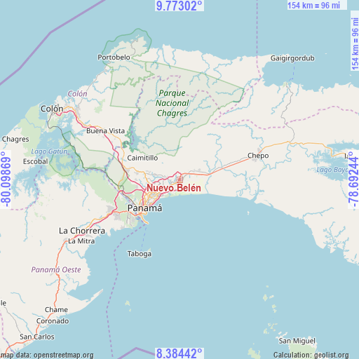
Nuevo Belén GPS coordinates[2]
9° 4' 45.804" North, 79° 23' 44.016" West
| Map corner | latitude | longitude |
|---|---|---|
| Upper-left | 9.77302°, | -80.09869° |
| Center: | 9.07939°, | -79.39556° |
| Lower-right: | 8.38442°, | -78.69244° |
| Map W x H: | 154.4×154.4 km | = 95.9×95.9mi |
| max Lat: | 9.60898° ⇑13.7% North |
| Nuevo Belén: | 9.07939° |
| min Lat: | ⇓86.3% South 7.26534° |
| min Long | Nuevo Belén | max Long |
| -82.91275° | -79.39556° | -77.38965° |
| W 88.7%⇐ | ⇒11.3% E |
Elevation
Elevation of Nuevo Belén is 19 m = 62 ft, and this is 153.1 m = 502 ft below average elevation for this country.
| Max E: |
2103 m = 6900 ft | 83.8% |
| Avg. | 172.1 m = 565 ft | |
| Nuevo Belén | 19 m = 62 ft | |
Min E: |
-1 m = -3 ft | 16.2% |
See also: Panama elevation on elevation.city.
Geographical zone
Nuevo Belén is located in North Torrid zone (between Equator and Tropic of Cancer). Distance of Equator is 1009.5 km =627.3 mi to South.| Distance of | km | miles | from Nuevo Belén |
|---|---|---|---|
| North Pole | 8997.5 | 5590.8 | to North |
| Arctic Circle | 6391.6 | 3971.6 | to North |
| Tropic Cancer | 1596.4 | 992 | to North |
| Equator | 1009.5 | 627.3 | to South |


Nearby cities:
15 places around Nuevo Belén: (largest is in red/bold)
• Cabra Número Uno
7.2 km =4.5 mi,  63°
63°
• Cerro Azul
9.1 km =5.7 mi,  342°
342°
• Gonzalillo
13.7 km =8.5 mi,  275°
275°
• Juan Díaz
6.8 km =4.2 mi,  241°
241°
• La Colorada
3.4 km =2.1 mi,  318°
318°
• Los Lotes
12.7 km =7.9 mi,  66°
66°
• Nueva Esperanza
7.2 km =4.5 mi, 69°
• Pacora
11.6 km =7.2 mi,  90°
90°
• Parque Lefevre
11.9 km =7.4 mi,  234°
234°
• Pedregal
4.4 km =2.7 mi,  251°
251°
• Rancho Café
5.6 km =3.5 mi,  26°
26°
• Río Abajo
13.4 km =8.3 mi, 238°
• San Miguelito
8.9 km =5.5 mi, 248°
• Tocumen
1.8 km =1.1 mi,  50°
50°
• Vista Hermosa
5.2 km =3.2 mi, 46°
Sources, notices
• [Note1] Compared only with cities in Panama existing in our database
• [Src1] Map data: © OpenStreetMap contributors (CC-BY-SA)
• [Src2] Other city data from geonames.org with taken over terms of usage.
• [Src3] Geographical zone / Annual Mean Temperature by Robert A. Rohde @ Wikipedia
