San Miguelito geodata
San Miguelito (Panamá) is a seat of a second-order administrative division; located in Panama in America/Panama (GMT-5) time zone. With population of 321,501 people, there is 1 city with bigger population in this country. Compared to other cities in Panama, 85.3% of cities are located further ↓South; 87.9% of cities are located further ←West and 58.6% of cities have higher elevation than San Miguelito. Note1


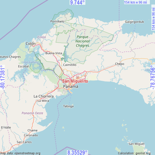
San Miguelito GPS coordinates[2]
9° 3' 1.152" North, 79° 28' 14.448" West
| Map corner | latitude | longitude |
|---|---|---|
| Upper-left | 9.744°, | -80.17381° |
| Center: | 9.05032°, | -79.47068° |
| Lower-right: | 8.35529°, | -78.76756° |
| Map W x H: | 154.4×154.4 km | = 95.9×95.9mi |
| max Lat: | 9.60898° ⇑14.7% North |
| San Miguelito: | 9.05032° |
| min Lat: | ⇓85.3% South 7.26534° |
| min Long | San Miguelito | max Long |
| -82.91275° | -79.47068° | -77.38965° |
| W 87.9%⇐ | ⇒12.1% E |
Elevation
Elevation of San Miguelito is 57 m = 187 ft, and this is 115.1 m = 378 ft below average elevation for this country.
| Max E: |
2103 m = 6900 ft | 58.6% |
| Avg. | 172.1 m = 565 ft | |
| San Miguelito | 57 m = 187 ft | |
Min E: |
-1 m = -3 ft | 41.4% |
See also: San Miguelito elevation on elevation.city.
Geographical zone
San Miguelito is located in North Torrid zone (between Equator and Tropic of Cancer). Distance of Equator is 1006.3 km =625.3 mi to South.| Distance of | km | miles | from San Miguelito |
|---|---|---|---|
| North Pole | 9000.8 | 5592.8 | to North |
| Arctic Circle | 6394.9 | 3973.6 | to North |
| Tropic Cancer | 1599.6 | 993.9 | to North |
| Equator | 1006.3 | 625.3 | to South |


Nearby cities:
15 places around San Miguelito: (largest is in red/bold)
• Alcalde Díaz
12.2 km =7.6 mi,  309°
309°
• Cerro Azul
13.1 km =8.1 mi,  24°
24°
• Curundú
12.1 km =7.5 mi,  223°
223°
• Gonzalillo
7.1 km =4.4 mi, 310°
• Juan Díaz
2.3 km =1.4 mi,  90°
90°
• La Cabima
10.5 km =6.5 mi,  316°
316°
• La Colorada
8.3 km =5.2 mi,  46°
46°
• Las Cumbres
7.6 km =4.7 mi,  304°
304°
• Mocambo Arriba
10.9 km =6.8 mi,  284°
284°
• Nuevo Belén
8.9 km =5.5 mi,  68°
68°
• Panamá
8.3 km =5.2 mi, 220°
• Parque Lefevre
4 km =2.5 mi,  200°
200°
• Pedregal
4.5 km =2.8 mi, 66°
• Río Abajo
4.9 km =3 mi, 220°
• Tocumen
10.6 km =6.6 mi, 65°
Sources, notices
• [Note1] Compared only with cities in Panama existing in our database
• [Src1] Map data: © OpenStreetMap contributors (CC-BY-SA)
• [Src2] Other city data from geonames.org with taken over terms of usage.
• [Src3] Geographical zone / Annual Mean Temperature by Robert A. Rohde @ Wikipedia
