Juan Gil geodata
Juan Gil (Panamá) is a populated place; located in Panama in America/Panama (GMT-5) time zone. With population of 652 people, there are 382 cities with bigger population in this country. Compared to other cities in Panama, 90.7% of cities are located further ↓South; 90.3% of cities are located further ←West and 51.1% of cities have lower elevation than Juan Gil. Note1


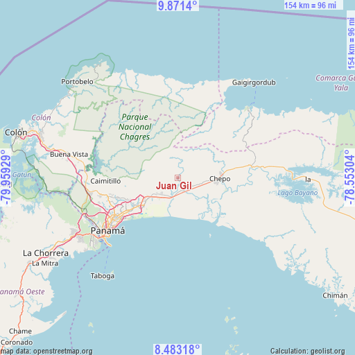
Juan Gil GPS coordinates[2]
9° 10' 40.692" North, 79° 15' 22.176" West
| Map corner | latitude | longitude |
|---|---|---|
| Upper-left | 9.8714°, | -79.95929° |
| Center: | 9.17797°, | -79.25616° |
| Lower-right: | 8.48318°, | -78.55304° |
| Map W x H: | 154.4×154.4 km | = 95.9×95.9mi |
| max Lat: | 9.60898° ⇑9.3% North |
| Juan Gil: | 9.17797° |
| min Lat: | ⇓90.7% South 7.26534° |
| min Long | Juan Gil | max Long |
| -82.91275° | -79.25616° | -77.38965° |
| W 90.3%⇐ | ⇒9.7% E |
Elevation
Elevation of Juan Gil is 75 m = 246 ft, and this is 97.1 m = 319 ft below average elevation for this country.
| Max E: |
2103 m = 6900 ft | 48.9% |
| Avg. | 172.1 m = 565 ft | |
| Juan Gil | 75 m = 246 ft | |
Min E: |
-1 m = -3 ft | 51.1% |
See also: Panama elevation on elevation.city.
Geographical zone
Juan Gil is located in North Torrid zone (between Equator and Tropic of Cancer). Distance of Equator is 1020.5 km =634.1 mi to South.| Distance of | km | miles | from Juan Gil |
|---|---|---|---|
| North Pole | 8986.6 | 5584 | to North |
| Arctic Circle | 6380.7 | 3964.8 | to North |
| Tropic Cancer | 1585.4 | 985.1 | to North |
| Equator | 1020.5 | 634.1 | to South |


Nearby cities:
15 places around Juan Gil: (largest is in red/bold)
• Cabra Número Uno
11.8 km =7.3 mi,  228°
228°
• Cerro Azul
18.2 km =11.3 mi,  262°
262°
• Chepo
17.1 km =10.6 mi,  92°
92°
• El Progreso
18.2 km =11.3 mi,  57°
57°
• La Mesa
2 km =1.2 mi,  254°
254°
• Los Lotes
7 km =4.3 mi,  211°
211°
• Naranjal
6.2 km =3.9 mi,  153°
153°
• Nueva Esperanza
12 km =7.5 mi, 225°
• Pacora
11.6 km =7.2 mi,  198°
198°
• Paso Blanco
5.7 km =3.5 mi,  167°
167°
• Rancho Café
14.1 km =8.8 mi, 245°
• San Miguel
4.2 km =2.6 mi,  0°
0°
• Tocumen
17.1 km =10.6 mi, 234°
• Unión de Azuero
9.9 km =6.2 mi,  106°
106°
• Vista Hermosa
13.7 km =8.5 mi,  237°
237°
Sources, notices
• [Note1] Compared only with cities in Panama existing in our database
• [Src1] Map data: © OpenStreetMap contributors (CC-BY-SA)
• [Src2] Other city data from geonames.org with taken over terms of usage.
• [Src3] Geographical zone / Annual Mean Temperature by Robert A. Rohde @ Wikipedia
