Potrero Grande geodata
Potrero Grande (Panamá Oeste) is a populated place; located in Panama in America/Panama (GMT-5) time zone. With population of 4,044 people, there are 76 cities with bigger population in this country. Compared to other cities in Panama, 78.5% of cities are located further ↓South; 79% of cities are located further ←West and 52.8% of cities have lower elevation than Potrero Grande. Note1


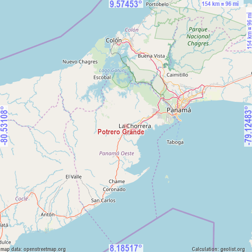
Potrero Grande GPS coordinates[2]
8° 52' 49.836" North, 79° 49' 40.62" West
| Map corner | latitude | longitude |
|---|---|---|
| Upper-left | 9.57453°, | -80.53108° |
| Center: | 8.88051°, | -79.82795° |
| Lower-right: | 8.18517°, | -79.12483° |
| Map W x H: | 154.5×154.5 km | = 96×96mi |
| max Lat: | 9.60898° ⇑21.5% North |
| Potrero Grande: | 8.88051° |
| min Lat: | ⇓78.5% South 7.26534° |
| min Long | Potrero Grande | max Long |
| -82.91275° | -79.82795° | -77.38965° |
| W 79%⇐ | ⇒21% E |
Elevation
Elevation of Potrero Grande is 80 m = 262 ft, and this is 92.1 m = 302 ft below average elevation for this country.
| Max E: |
2103 m = 6900 ft | 47.2% |
| Avg. | 172.1 m = 565 ft | |
| Potrero Grande | 80 m = 262 ft | |
Min E: |
-1 m = -3 ft | 52.8% |
See also: Panama elevation on elevation.city.
Geographical zone
Potrero Grande is located in North Torrid zone (between Equator and Tropic of Cancer). Distance of Equator is 987.4 km =613.5 mi to South.| Distance of | km | miles | from Potrero Grande |
|---|---|---|---|
| North Pole | 9019.6 | 5604.5 | to North |
| Arctic Circle | 6413.8 | 3985.3 | to North |
| Tropic Cancer | 1618.5 | 1005.7 | to North |
| Equator | 987.4 | 613.5 | to South |


Nearby cities:
15 places around Potrero Grande: (largest is in red/bold)
• Alto del Espino
4.7 km =2.9 mi,  204°
204°
• Altos de San Francisco
4.7 km =2.9 mi,  116°
116°
• El Coco
2.9 km =1.8 mi,  113°
113°
• El Espino
5.3 km =3.3 mi,  206°
206°
• Guadalupe
3.3 km =2.1 mi,  152°
152°
• La Chorrera
4.9 km =3 mi,  90°
90°
• La Herradura
4.4 km =2.7 mi,  143°
143°
• La Mitra
6.3 km =3.9 mi,  134°
134°
• La Pesa
3.3 km =2.1 mi,  172°
172°
• La Pita
7.2 km =4.5 mi, 199°
• Las Ollas Abajo
10.1 km =6.3 mi,  244°
244°
• Llano Largo
5.6 km =3.5 mi,  156°
156°
• Santa Rita
6.3 km =3.9 mi,  245°
245°
• Villa Carmen
10.2 km =6.3 mi, 206°
• Zangüengas
9.6 km =6 mi,  330°
330°
Sources, notices
• [Note1] Compared only with cities in Panama existing in our database
• [Src1] Map data: © OpenStreetMap contributors (CC-BY-SA)
• [Src2] Other city data from geonames.org with taken over terms of usage.
• [Src3] Geographical zone / Annual Mean Temperature by Robert A. Rohde @ Wikipedia
