Guadalupe geodata
Guadalupe (Panamá Oeste) is a seat of a third-order administrative division; located in Panama in America/Panama (GMT-5) time zone. With population of 6,561 people, there are 57 cities with bigger population in this country. Compared to other cities in Panama, 77.1% of cities are located further ↓South; 79.3% of cities are located further ←West and 56.4% of cities have lower elevation than Guadalupe. Note1


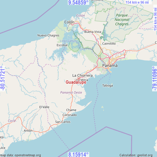
Guadalupe GPS coordinates[2]
8° 51' 16.272" North, 79° 48' 50.688" West
| Map corner | latitude | longitude |
|---|---|---|
| Upper-left | 9.54859°, | -80.51721° |
| Center: | 8.85452°, | -79.81408° |
| Lower-right: | 8.15914°, | -79.11096° |
| Map W x H: | 154.5×154.5 km | = 96×96mi |
| max Lat: | 9.60898° ⇑22.9% North |
| Guadalupe: | 8.85452° |
| min Lat: | ⇓77.1% South 7.26534° |
| min Long | Guadalupe | max Long |
| -82.91275° | -79.81408° | -77.38965° |
| W 79.3%⇐ | ⇒20.7% E |
Elevation
Elevation of Guadalupe is 92 m = 302 ft, and this is 80.1 m = 263 ft below average elevation for this country.
| Max E: |
2103 m = 6900 ft | 43.6% |
| Avg. | 172.1 m = 565 ft | |
| Guadalupe | 92 m = 302 ft | |
Min E: |
-1 m = -3 ft | 56.4% |
See also: Panama elevation on elevation.city.
Geographical zone
Guadalupe is located in North Torrid zone (between Equator and Tropic of Cancer). Distance of Equator is 984.5 km =611.7 mi to South.| Distance of | km | miles | from Guadalupe |
|---|---|---|---|
| North Pole | 9022.5 | 5606.3 | to North |
| Arctic Circle | 6416.6 | 3987.1 | to North |
| Tropic Cancer | 1621.4 | 1007.5 | to North |
| Equator | 984.5 | 611.7 | to South |


Nearby cities:
15 places around Guadalupe: (largest is in red/bold)
• Alto del Espino
3.7 km =2.3 mi,  248°
248°
• Altos de San Francisco
2.8 km =1.7 mi,  73°
73°
• El Coco
2 km =1.2 mi,  32°
32°
• El Espino
4.3 km =2.7 mi,  244°
244°
• La Chorrera
4.4 km =2.7 mi,  49°
49°
• La Herradura
1.3 km =0.8 mi,  121°
121°
• La Mitra
3.4 km =2.1 mi, 116°
• La Pesa
1.1 km =0.7 mi, 248°
• La Pita
5.5 km =3.4 mi,  224°
224°
• Las Ollas Abajo
10.7 km =6.6 mi,  262°
262°
• Llano Largo
2.3 km =1.4 mi,  162°
162°
• Playa Leona
8.9 km =5.5 mi,  151°
151°
• Potrero Grande
3.3 km =2.1 mi,  332°
332°
• Santa Rita
7.2 km =4.5 mi,  272°
272°
• Villa Carmen
8.7 km =5.4 mi, 224°
Sources, notices
• [Note1] Compared only with cities in Panama existing in our database
• [Src1] Map data: © OpenStreetMap contributors (CC-BY-SA)
• [Src2] Other city data from geonames.org with taken over terms of usage.
• [Src3] Geographical zone / Annual Mean Temperature by Robert A. Rohde @ Wikipedia
