Las Ollas Abajo geodata
Las Ollas Abajo (Panamá Oeste) is a populated place; located in Panama in America/Panama (GMT-5) time zone. With population of 566 people, there are 430 cities with bigger population in this country. Compared to other cities in Panama, 75.8% of cities are located further ↓South; 75.3% of cities are located further ←West and 63.7% of cities have lower elevation than Las Ollas Abajo. Note1


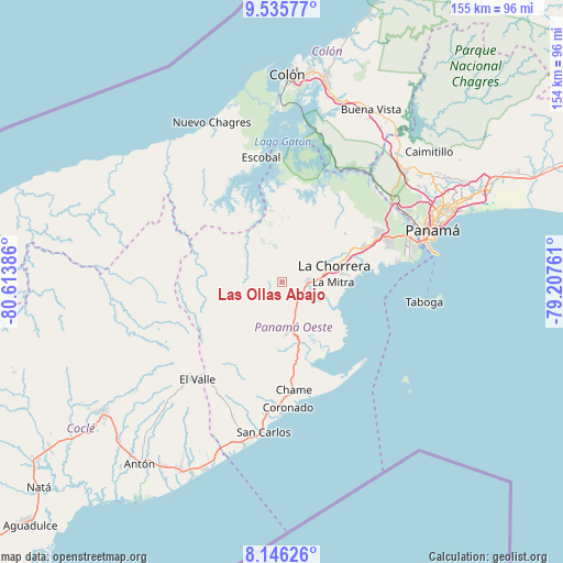
Las Ollas Abajo GPS coordinates[2]
8° 50' 30.012" North, 79° 54' 38.628" West
| Map corner | latitude | longitude |
|---|---|---|
| Upper-left | 9.53577°, | -80.61386° |
| Center: | 8.84167°, | -79.91073° |
| Lower-right: | 8.14626°, | -79.20761° |
| Map W x H: | 154.5×154.5 km | = 96×96mi |
| max Lat: | 9.60898° ⇑24.2% North |
| Las Ollas Abajo: | 8.84167° |
| min Lat: | ⇓75.8% South 7.26534° |
| min Long | Las Ollas Abajo | max Long |
| -82.91275° | -79.91073° | -77.38965° |
| W 75.3%⇐ | ⇒24.7% E |
Elevation
Elevation of Las Ollas Abajo is 121 m = 397 ft, and this is 51.1 m = 168 ft below average elevation for this country.
| Max E: |
2103 m = 6900 ft | 36.3% |
| Avg. | 172.1 m = 565 ft | |
| Las Ollas Abajo | 121 m = 397 ft | |
Min E: |
-1 m = -3 ft | 63.7% |
See also: Panama elevation on elevation.city.
Geographical zone
Las Ollas Abajo is located in North Torrid zone (between Equator and Tropic of Cancer). Distance of Equator is 983.1 km =610.9 mi to South.| Distance of | km | miles | from Las Ollas Abajo |
|---|---|---|---|
| North Pole | 9024 | 5607.3 | to North |
| Arctic Circle | 6418.1 | 3988 | to North |
| Tropic Cancer | 1622.8 | 1008.4 | to North |
| Equator | 983.1 | 610.9 | to South |


Nearby cities:
15 places around Las Ollas Abajo: (largest is in red/bold)
• Alto del Espino
7.2 km =4.5 mi,  89°
89°
• Caimito
5.2 km =3.2 mi,  230°
230°
• Capira
10.1 km =6.3 mi,  160°
160°
• El Espino
6.8 km =4.2 mi, 93°
• Guadalupe
10.7 km =6.6 mi,  82°
82°
• La Pesa
9.6 km =6 mi, 83°
• La Pita
7.2 km =4.5 mi,  110°
110°
• Las Ollas Arriba
3.9 km =2.4 mi,  183°
183°
• Llano de Santa Rosa
10.4 km =6.5 mi,  149°
149°
• Lídice
10.3 km =6.4 mi, 179°
• Nueva Arenosa
9.7 km =6 mi,  288°
288°
• Potrero Grande
10.1 km =6.3 mi,  64°
64°
• Santa Rita
3.8 km =2.4 mi, 63°
• Villa Carmen
6.6 km =4.1 mi,  136°
136°
• Villa Rosario
8.5 km =5.3 mi, 152°
Sources, notices
• [Note1] Compared only with cities in Panama existing in our database
• [Src1] Map data: © OpenStreetMap contributors (CC-BY-SA)
• [Src2] Other city data from geonames.org with taken over terms of usage.
• [Src3] Geographical zone / Annual Mean Temperature by Robert A. Rohde @ Wikipedia
