Portobelo geodata
Portobelo (Colón) is a seat of a third-order administrative division; located in Panama in America/Panama (GMT-5) time zone. With population of 1,393 people, there are 171 cities with bigger population in this country. Compared to other cities in Panama, 99.1% of cities are located further ↓South; 84% of cities are located further ←West and 91.8% of cities have higher elevation than Portobelo. Note1


Portobelo GPS coordinates[2]
9° 33' 10.908" North, 79° 39' 24.948" West
| Map corner | latitude | longitude |
|---|---|---|
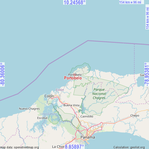
| Upper-left | 10.24568°, | -80.36006° |
| Center: | 9.55303°, | -79.65693° |
| Lower-right: | 8.85897°, | -78.95381° |
| Map W x H: | 154.2×154.2 km | = 95.8×95.8mi |
| max Lat: | 9.60898° ⇑0.9% North |
| Portobelo: | 9.55303° |
| min Lat: | ⇓99.1% South 7.26534° |
| min Long | Portobelo | max Long |
| -82.91275° | -79.65693° | -77.38965° |
| W 84%⇐ | ⇒16% E |
Elevation
Elevation of Portobelo is 11 m = 36 ft, and this is 161.1 m = 529 ft below average elevation for this country.
| Max E: |
2103 m = 6900 ft | 91.8% |
| Avg. | 172.1 m = 565 ft | |
| Portobelo | 11 m = 36 ft | |
Min E: |
-1 m = -3 ft | 8.2% |
See also: Panama elevation on elevation.city.
Geographical zone
Portobelo is located in North Torrid zone (between Equator and Tropic of Cancer). Distance of Equator is 1062.2 km =660 mi to South.| Distance of | km | miles | from Portobelo |
|---|---|---|---|
| North Pole | 8944.9 | 5558.1 | to North |
| Arctic Circle | 6339 | 3938.9 | to North |
| Tropic Cancer | 1543.7 | 959.2 | to North |
| Equator | 1062.2 | 660 | to South |


Nearby cities:
15 places around Portobelo: (largest is in red/bold)
• Buena Vista
31.4 km =19.5 mi,  187°
187°
• Cacique
7.6 km =4.7 mi,  35°
35°
• Cativá
28.6 km =17.8 mi,  222°
222°
• María Chiquita
16.5 km =10.3 mi, 220°
• Nombre de Dios
20.6 km =12.8 mi,  81°
81°
• Nuevo Tonosí
3.8 km =2.4 mi,  94°
94°
• Puerto Pilón
25.9 km =16.1 mi, 215°
• Quebrada Bonita Adentro
29 km =18 mi, 190°
• Río Alejandro
24.8 km =15.4 mi, 215°
• Sabanitas
28.8 km =17.9 mi, 215°
• Salamanca
24.9 km =15.5 mi,  166°
166°
• Santa Rita Arriba
28.9 km =18 mi,  211°
211°
• Sardinilla
28.4 km =17.6 mi,  176°
176°
• Viento Frío
27.6 km =17.1 mi, 83°
• Villa Alondra
23 km =14.3 mi, 216°
Sources, notices
• [Note1] Compared only with cities in Panama existing in our database
• [Src1] Map data: © OpenStreetMap contributors (CC-BY-SA)
• [Src2] Other city data from geonames.org with taken over terms of usage.
• [Src3] Geographical zone / Annual Mean Temperature by Robert A. Rohde @ Wikipedia
