Playa Leona geodata
Playa Leona (Panamá Oeste) is a seat of a third-order administrative division; located in Panama in America/Panama (GMT-5) time zone. With population of 556 people, there are 437 cities with bigger population in this country. Compared to other cities in Panama, 72.9% of cities are located further ↓South; 81% of cities are located further ←West and 77% of cities have higher elevation than Playa Leona. Note1


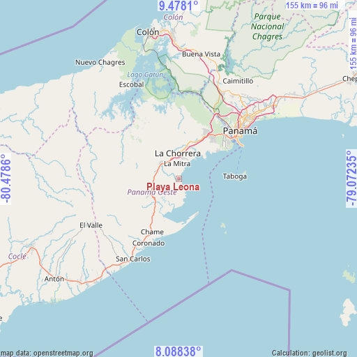
Playa Leona GPS coordinates[2]
8° 47' 2.004" North, 79° 46' 31.692" West
| Map corner | latitude | longitude |
|---|---|---|
| Upper-left | 9.4781°, | -80.4786° |
| Center: | 8.78389°, | -79.77547° |
| Lower-right: | 8.08838°, | -79.07235° |
| Map W x H: | 154.5×154.5 km | = 96×96mi |
| max Lat: | 9.60898° ⇑27.1% North |
| Playa Leona: | 8.78389° |
| min Lat: | ⇓72.9% South 7.26534° |
| min Long | Playa Leona | max Long |
| -82.91275° | -79.77547° | -77.38965° |
| W 81%⇐ | ⇒19% E |
Elevation
Elevation of Playa Leona is 28 m = 92 ft, and this is 144.1 m = 473 ft below average elevation for this country.
| Max E: |
2103 m = 6900 ft | 77% |
| Avg. | 172.1 m = 565 ft | |
| Playa Leona | 28 m = 92 ft | |
Min E: |
-1 m = -3 ft | 23% |
See also: Panama elevation on elevation.city.
Geographical zone
Playa Leona is located in North Torrid zone (between Equator and Tropic of Cancer). Distance of Equator is 976.7 km =606.9 mi to South.| Distance of | km | miles | from Playa Leona |
|---|---|---|---|
| North Pole | 9030.4 | 5611.2 | to North |
| Arctic Circle | 6424.5 | 3992 | to North |
| Tropic Cancer | 1629.2 | 1012.3 | to North |
| Equator | 976.7 | 606.9 | to South |


Nearby cities:
15 places around Playa Leona: (largest is in red/bold)
• Alto del Espino
10.1 km =6.3 mi,  310°
310°
• Altos de San Francisco
8.8 km =5.5 mi,  349°
349°
• Cermeño
9.8 km =6.1 mi,  240°
240°
• El Coco
10.1 km =6.3 mi,  341°
341°
• El Espino
10.1 km =6.3 mi, 306°
• Guadalupe
8.9 km =5.5 mi,  331°
331°
• La Chorrera
10.8 km =6.7 mi,  355°
355°
• La Herradura
7.8 km =4.8 mi, 336°
• La Mitra
6.5 km =4 mi, 349°
• La Pesa
9.1 km =5.7 mi,  324°
324°
• La Pita
9 km =5.6 mi,  295°
295°
• Llano Largo
6.7 km =4.2 mi, 327°
• Llano de Santa Rosa
10 km =6.2 mi,  254°
254°
• Villa Carmen
10.4 km =6.5 mi,  278°
278°
• Villa Rosario
11 km =6.8 mi,  264°
264°
Sources, notices
• [Note1] Compared only with cities in Panama existing in our database
• [Src1] Map data: © OpenStreetMap contributors (CC-BY-SA)
• [Src2] Other city data from geonames.org with taken over terms of usage.
• [Src3] Geographical zone / Annual Mean Temperature by Robert A. Rohde @ Wikipedia
