Cermeño geodata
Cermeño (Panamá Oeste) is a seat of a third-order administrative division; located in Panama in America/Panama (GMT-5) time zone. With population of 928 people, there are 274 cities with bigger population in this country. Compared to other cities in Panama, 71.4% of cities are located further ↓South; 78% of cities are located further ←West and 75.9% of cities have lower elevation than Cermeño. Note1


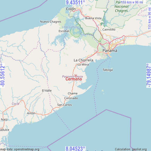
Cermeño GPS coordinates[2]
8° 44' 26.952" North, 79° 51' 10.764" West
| Map corner | latitude | longitude |
|---|---|---|
| Upper-left | 9.43511°, | -80.55612° |
| Center: | 8.74082°, | -79.85299° |
| Lower-right: | 8.04523°, | -79.14987° |
| Map W x H: | 154.5×154.5 km | = 96×96mi |
| max Lat: | 9.60898° ⇑28.6% North |
| Cermeño: | 8.74082° |
| min Lat: | ⇓71.4% South 7.26534° |
| min Long | Cermeño | max Long |
| -82.91275° | -79.85299° | -77.38965° |
| W 78%⇐ | ⇒22% E |
Elevation
Elevation of Cermeño is 207 m = 679 ft, and this is 34.9 m = 115 ft above average elevation for this country.
| Max E: |
2103 m = 6900 ft | 24.1% |
| Cermeño | 207 m 679 ft | |
| Avg. | 172.1 m = 565 ft | |
Min E: |
-1 m = -3 ft | 75.9% |
See also: Panama elevation on elevation.city.
Geographical zone
Cermeño is located in North Torrid zone (between Equator and Tropic of Cancer). Distance of Equator is 971.9 km =603.9 mi to South.| Distance of | km | miles | from Cermeño |
|---|---|---|---|
| North Pole | 9035.2 | 5614.2 | to North |
| Arctic Circle | 6429.3 | 3995 | to North |
| Tropic Cancer | 1634 | 1015.3 | to North |
| Equator | 971.9 | 603.9 | to South |


Nearby cities:
15 places around Cermeño: (largest is in red/bold)
• Alto del Espino
11.3 km =7 mi,  4°
4°
• Capira
3.4 km =2.1 mi,  300°
300°
• Cerro Campana
7.5 km =4.7 mi,  239°
239°
• El Alto de Capira
3.9 km =2.4 mi,  256°
256°
• El Espavé
9.2 km =5.7 mi,  195°
195°
• El Espino
10.8 km =6.7 mi, 2°
• La Pita
8.7 km =5.4 mi, 2°
• Las Ollas Arriba
9.9 km =6.2 mi,  317°
317°
• Llano Largo
11.6 km =7.2 mi,  25°
25°
• Llano de Santa Rosa
2.5 km =1.6 mi,  333°
333°
• Lídice
6.3 km =3.9 mi,  277°
277°
• Playa Leona
9.8 km =6.1 mi,  60°
60°
• Sajalices
6.7 km =4.2 mi,  193°
193°
• Villa Carmen
6.6 km =4.1 mi,  344°
344°
• Villa Rosario
4.4 km =2.7 mi, 326°
Sources, notices
• [Note1] Compared only with cities in Panama existing in our database
• [Src1] Map data: © OpenStreetMap contributors (CC-BY-SA)
• [Src2] Other city data from geonames.org with taken over terms of usage.
• [Src3] Geographical zone / Annual Mean Temperature by Robert A. Rohde @ Wikipedia
