Lídice geodata
Lídice (Panamá) is a populated place; located in Panama in America/Panama (GMT-5) time zone. With population of 4,245 people, there are 71 cities with bigger population in this country. Compared to other cities in Panama, 71.8% of cities are located further ↓South; 75.4% of cities are located further ←West and 65.9% of cities have lower elevation than Lídice. Note1


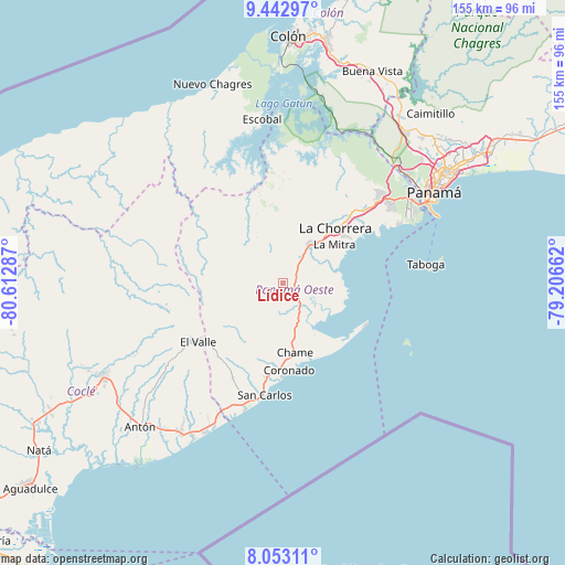
Lídice GPS coordinates[2]
8° 44' 55.284" North, 79° 54' 35.064" West
| Map corner | latitude | longitude |
|---|---|---|
| Upper-left | 9.44297°, | -80.61287° |
| Center: | 8.74869°, | -79.90974° |
| Lower-right: | 8.05311°, | -79.20662° |
| Map W x H: | 154.5×154.5 km | = 96×96mi |
| max Lat: | 9.60898° ⇑28.2% North |
| Lídice: | 8.74869° |
| min Lat: | ⇓71.8% South 7.26534° |
| min Long | Lídice | max Long |
| -82.91275° | -79.90974° | -77.38965° |
| W 75.4%⇐ | ⇒24.6% E |
Elevation
Elevation of Lídice is 128 m = 420 ft, and this is 44.1 m = 145 ft below average elevation for this country.
| Max E: |
2103 m = 6900 ft | 34.1% |
| Avg. | 172.1 m = 565 ft | |
| Lídice | 128 m = 420 ft | |
Min E: |
-1 m = -3 ft | 65.9% |
See also: Panama elevation on elevation.city.
Geographical zone
Lídice is located in North Torrid zone (between Equator and Tropic of Cancer). Distance of Equator is 972.8 km =604.5 mi to South.| Distance of | km | miles | from Lídice |
|---|---|---|---|
| North Pole | 9034.3 | 5613.7 | to North |
| Arctic Circle | 6428.4 | 3994.4 | to North |
| Tropic Cancer | 1633.2 | 1014.8 | to North |
| Equator | 972.8 | 604.5 | to South |


Nearby cities:
15 places around Lídice: (largest is in red/bold)
• Caimito
8.1 km =5 mi,  329°
329°
• Capira
3.4 km =2.1 mi,  75°
75°
• Cermeño
6.3 km =3.9 mi,  97°
97°
• Cerro Campana
4.7 km =2.9 mi,  183°
183°
• El Alto de Capira
3 km =1.9 mi,  126°
126°
• El Cacao
11.4 km =7.1 mi,  277°
277°
• El Espavé
10.4 km =6.5 mi,  158°
158°
• El Espino
11.9 km =7.4 mi,  33°
33°
• La Pita
10.2 km =6.3 mi,  40°
40°
• Las Ollas Abajo
10.3 km =6.4 mi,  359°
359°
• Las Ollas Arriba
6.5 km =4 mi, 356°
• Llano de Santa Rosa
5.3 km =3.3 mi, 75°
• Sajalices
8.8 km =5.5 mi,  148°
148°
• Villa Carmen
7.1 km =4.4 mi, 38°
• Villa Rosario
4.7 km =2.9 mi,  53°
53°
Sources, notices
• [Note1] Compared only with cities in Panama existing in our database
• [Src1] Map data: © OpenStreetMap contributors (CC-BY-SA)
• [Src2] Other city data from geonames.org with taken over terms of usage.
• [Src3] Geographical zone / Annual Mean Temperature by Robert A. Rohde @ Wikipedia
