La Soledad geodata
La Soledad (Veraguas) is a seat of a third-order administrative division; located in Panama in America/Panama (GMT-5) time zone. In our database, there are 694 cities with bigger population. Compared to other cities in Panama, 87.4% of cities are located further ↑North; 66.5% of cities are located further →East and 75.7% of cities have higher elevation than La Soledad. Note1


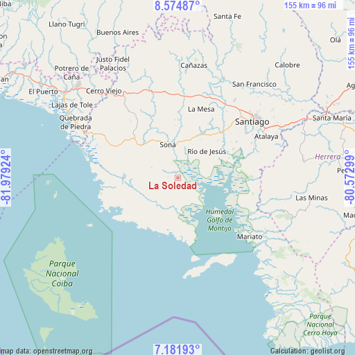
La Soledad GPS coordinates[2]
7° 52' 44.364" North, 81° 16' 33.996" West
| Map corner | latitude | longitude |
|---|---|---|
| Upper-left | 8.57487°, | -81.97924° |
| Center: | 7.87899°, | -81.27611° |
| Lower-right: | 7.18193°, | -80.57299° |
| Map W x H: | 154.9×154.9 km | = 96.3×96.3mi |
| max Lat: | 9.60898° ⇑87.4% North |
| La Soledad: | 7.87899° |
| min Lat: | ⇓12.6% South 7.26534° |
| min Long | La Soledad | max Long |
| -82.91275° | -81.27611° | -77.38965° |
| W 33.5%⇐ | ⇒66.5% E |
Elevation
Elevation of La Soledad is 29 m = 95 ft, and this is 143.1 m = 469 ft below average elevation for this country.
| Max E: |
2103 m = 6900 ft | 75.7% |
| Avg. | 172.1 m = 565 ft | |
| La Soledad | 29 m = 95 ft | |
Min E: |
-1 m = -3 ft | 24.3% |
See also: Panama elevation on elevation.city.
Geographical zone
La Soledad is located in North Torrid zone (between Equator and Tropic of Cancer). Distance of Equator is 876.1 km =544.4 mi to South.| Distance of | km | miles | from La Soledad |
|---|---|---|---|
| North Pole | 9131 | 5673.7 | to North |
| Arctic Circle | 6525.1 | 4054.5 | to North |
| Tropic Cancer | 1729.9 | 1074.9 | to North |
| Equator | 876.1 | 544.4 | to South |


Nearby cities:
15 places around La Soledad: (largest is in red/bold)
• Calidonia
15 km =9.3 mi,  305°
305°
• El Marañón
18.7 km =11.6 mi,  21°
21°
• El Pilón
23.5 km =14.6 mi,  69°
69°
• El Pájaro
18.9 km =11.7 mi,  64°
64°
• Guarumal
9.6 km =6 mi,  168°
168°
• La Tollosa
13.3 km =8.3 mi,  336°
336°
• Las Huacas
15.1 km =9.4 mi,  80°
80°
• Leones Arriba
22.5 km =14 mi,  128°
128°
• Quebrada de Oro
21.3 km =13.2 mi,  324°
324°
• Río Grande
18.9 km =11.7 mi,  199°
199°
• Río de Jesús
16.8 km =10.4 mi,  48°
48°
• San Francisco
23.1 km =14.4 mi,  334°
334°
• Soná
15.6 km =9.7 mi, 341°
• Tríbique
13.6 km =8.5 mi, 341°
• Utirá
12.2 km =7.6 mi,  31°
31°
Sources, notices
• [Note1] Compared only with cities in Panama existing in our database
• [Src1] Map data: © OpenStreetMap contributors (CC-BY-SA)
• [Src2] Other city data from geonames.org with taken over terms of usage.
• [Src3] Geographical zone / Annual Mean Temperature by Robert A. Rohde @ Wikipedia
