Guarumal geodata
Guarumal (Veraguas) is a seat of a third-order administrative division; located in Panama in America/Panama (GMT-5) time zone. With population of 477 people, there are 496 cities with bigger population in this country. Compared to other cities in Panama, 90.3% of cities are located further ↑North; 66.2% of cities are located further →East and 68.9% of cities have higher elevation than Guarumal. Note1


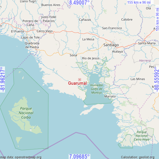
Guarumal GPS coordinates[2]
7° 47' 38.544" North, 81° 15' 32.544" West
| Map corner | latitude | longitude |
|---|---|---|
| Upper-left | 8.49007°, | -81.96217° |
| Center: | 7.79404°, | -81.25904° |
| Lower-right: | 7.09685°, | -80.55592° |
| Map W x H: | 154.9×154.9 km | = 96.3×96.3mi |
| max Lat: | 9.60898° ⇑90.3% North |
| Guarumal: | 7.79404° |
| min Lat: | ⇓9.7% South 7.26534° |
| min Long | Guarumal | max Long |
| -82.91275° | -81.25904° | -77.38965° |
| W 33.8%⇐ | ⇒66.2% E |
Elevation
Elevation of Guarumal is 37 m = 121 ft, and this is 135.1 m = 443 ft below average elevation for this country.
| Max E: |
2103 m = 6900 ft | 68.9% |
| Avg. | 172.1 m = 565 ft | |
| Guarumal | 37 m = 121 ft | |
Min E: |
-1 m = -3 ft | 31.1% |
See also: Panama elevation on elevation.city.
Geographical zone
Guarumal is located in North Torrid zone (between Equator and Tropic of Cancer). Distance of Equator is 866.6 km =538.5 mi to South.| Distance of | km | miles | from Guarumal |
|---|---|---|---|
| North Pole | 9140.4 | 5679.6 | to North |
| Arctic Circle | 6534.6 | 4060.4 | to North |
| Tropic Cancer | 1739.3 | 1080.8 | to North |
| Equator | 866.6 | 538.5 | to South |


Nearby cities:
15 places around Guarumal: (largest is in red/bold)
• Calidonia
23 km =14.3 mi,  322°
322°
• El Pilón
26.9 km =16.7 mi,  48°
48°
• El Pájaro
23.3 km =14.5 mi,  40°
40°
• Hicaco
16.7 km =10.4 mi,  159°
159°
• La Soledad
9.6 km =6 mi,  348°
348°
• La Tollosa
22.9 km =14.2 mi,  341°
341°
• Las Huacas
17.7 km =11 mi, 47°
• Leones Arriba
16.4 km =10.2 mi,  105°
105°
• Rincón Largo
27.1 km =16.8 mi, 51°
• Río Grande
11.8 km =7.3 mi,  224°
224°
• Río de Jesús
23.2 km =14.4 mi,  27°
27°
• Santa Catalina
18.1 km =11.2 mi,  178°
178°
• Soná
25.2 km =15.7 mi, 344°
• Tríbique
23.2 km =14.4 mi, 344°
• Utirá
20.3 km =12.6 mi,  12°
12°
Sources, notices
• [Note1] Compared only with cities in Panama existing in our database
• [Src1] Map data: © OpenStreetMap contributors (CC-BY-SA)
• [Src2] Other city data from geonames.org with taken over terms of usage.
• [Src3] Geographical zone / Annual Mean Temperature by Robert A. Rohde @ Wikipedia
