Río Grande geodata
Río Grande (Veraguas) is a seat of a third-order administrative division; located in Panama in America/Panama (GMT-5) time zone. With population of 71 people, there are 677 cities with bigger population in this country. Compared to other cities in Panama, 93.3% of cities are located further ↑North; 67.5% of cities are located further →East and 69.8% of cities have higher elevation than Río Grande. Note1


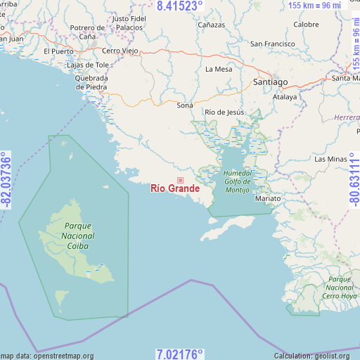
Río Grande GPS coordinates[2]
7° 43' 8.652" North, 81° 20' 3.228" West
| Map corner | latitude | longitude |
|---|---|---|
| Upper-left | 8.41523°, | -82.03736° |
| Center: | 7.71907°, | -81.33423° |
| Lower-right: | 7.02176°, | -80.63111° |
| Map W x H: | 154.9×154.9 km | = 96.3×96.3mi |
| max Lat: | 9.60898° ⇑93.3% North |
| Río Grande: | 7.71907° |
| min Lat: | ⇓6.7% South 7.26534° |
| min Long | Río Grande | max Long |
| -82.91275° | -81.33423° | -77.38965° |
| W 32.5%⇐ | ⇒67.5% E |
Elevation
Elevation of Río Grande is 36 m = 118 ft, and this is 136.1 m = 447 ft below average elevation for this country.
| Max E: |
2103 m = 6900 ft | 69.8% |
| Avg. | 172.1 m = 565 ft | |
| Río Grande | 36 m = 118 ft | |
Min E: |
-1 m = -3 ft | 30.2% |
See also: Panama elevation on elevation.city.
Geographical zone
Río Grande is located in North Torrid zone (between Equator and Tropic of Cancer). Distance of Equator is 858.3 km =533.3 mi to South.| Distance of | km | miles | from Río Grande |
|---|---|---|---|
| North Pole | 9148.8 | 5684.8 | to North |
| Arctic Circle | 6542.9 | 4065.6 | to North |
| Tropic Cancer | 1747.6 | 1085.9 | to North |
| Equator | 858.3 | 533.3 | to South |


Nearby cities:
15 places around Río Grande: (largest is in red/bold)
• Calidonia
27.1 km =16.8 mi,  347°
347°
• El Pájaro
35 km =21.7 mi,  41°
41°
• Guarumal
11.8 km =7.3 mi, 44°
• Hicaco
16 km =9.9 mi,  116°
116°
• La Punta
23.9 km =14.9 mi,  138°
138°
• La Soledad
18.9 km =11.7 mi,  19°
19°
• La Tollosa
30.1 km =18.7 mi,  2°
2°
• Las Huacas
29.5 km =18.3 mi,  46°
46°
• Leones Arriba
24.4 km =15.2 mi,  80°
80°
• Quebrada de Oro
35.7 km =22.2 mi, 350°
• Río de Jesús
34.6 km =21.5 mi,  33°
33°
• Santa Catalina
13.2 km =8.2 mi, 137°
• Soná
32.6 km =20.3 mi, 2°
• Tríbique
30.7 km =19.1 mi, 3°
• Utirá
30.9 km =19.2 mi, 24°
Sources, notices
• [Note1] Compared only with cities in Panama existing in our database
• [Src1] Map data: © OpenStreetMap contributors (CC-BY-SA)
• [Src2] Other city data from geonames.org with taken over terms of usage.
• [Src3] Geographical zone / Annual Mean Temperature by Robert A. Rohde @ Wikipedia
