Santa Lucia geodata
Santa Lucia (Chiriquí) is a seat of a third-order administrative division; located in Panama in America/Panama (GMT-5) time zone. In our database, there are 694 cities with bigger population. Compared to other cities in Panama, 70.9% of cities are located further ↑North; 75.7% of cities are located further →East and 64.2% of cities have higher elevation than Santa Lucia. Note1


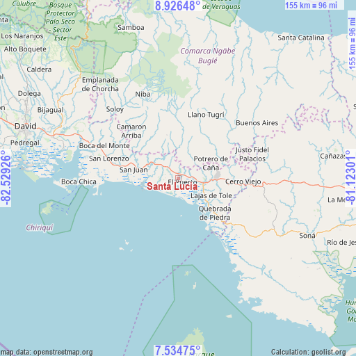
Santa Lucia GPS coordinates[2]
8° 13' 52.428" North, 81° 49' 34.068" West
| Map corner | latitude | longitude |
|---|---|---|
| Upper-left | 8.92648°, | -82.52926° |
| Center: | 8.23123°, | -81.82613° |
| Lower-right: | 7.53475°, | -81.12301° |
| Map W x H: | 154.7×154.7 km | = 96.1×96.1mi |
| max Lat: | 9.60898° ⇑70.9% North |
| Santa Lucia: | 8.23123° |
| min Lat: | ⇓29.1% South 7.26534° |
| min Long | Santa Lucia | max Long |
| -82.91275° | -81.82613° | -77.38965° |
| W 24.3%⇐ | ⇒75.7% E |
Elevation
Elevation of Santa Lucia is 46 m = 151 ft, and this is 126.1 m = 414 ft below average elevation for this country.
| Max E: |
2103 m = 6900 ft | 64.2% |
| Avg. | 172.1 m = 565 ft | |
| Santa Lucia | 46 m = 151 ft | |
Min E: |
-1 m = -3 ft | 35.8% |
See also: Panama elevation on elevation.city.
Geographical zone
Santa Lucia is located in North Torrid zone (between Equator and Tropic of Cancer). Distance of Equator is 915.2 km =568.7 mi to South.| Distance of | km | miles | from Santa Lucia |
|---|---|---|---|
| North Pole | 9091.8 | 5649.4 | to North |
| Arctic Circle | 6485.9 | 4030.2 | to North |
| Tropic Cancer | 1690.7 | 1050.6 | to North |
| Equator | 915.2 | 568.7 | to South |


Nearby cities:
15 places around Santa Lucia: (largest is in red/bold)
• Cabecera de Cerro Puerco
12.2 km =7.6 mi,  37°
37°
• Cerro Ceniza
14.1 km =8.8 mi,  27°
27°
• Cerro Iglesias
6.8 km =4.2 mi, 27°
• El Nancito
10.4 km =6.5 mi,  85°
85°
• El Porvenir
0.8 km =0.5 mi,  252°
252°
• El Puerto
2.9 km =1.8 mi,  136°
136°
• Hato Juli
13.3 km =8.3 mi,  351°
351°
• Lajas Adentro
6 km =3.7 mi,  289°
289°
• Lajero Arriba
9 km =5.6 mi, 42°
• Las Lajas
4.9 km =3 mi,  283°
283°
• Las Matas
8.8 km =5.5 mi,  329°
329°
• Oma
13.5 km =8.4 mi,  11°
11°
• Remedios
0.8 km =0.5 mi,  190°
190°
• San Félix
8 km =5 mi, 325°
• Santa Cruz
9.6 km =6 mi,  270°
270°
Sources, notices
• [Note1] Compared only with cities in Panama existing in our database
• [Src1] Map data: © OpenStreetMap contributors (CC-BY-SA)
• [Src2] Other city data from geonames.org with taken over terms of usage.
• [Src3] Geographical zone / Annual Mean Temperature by Robert A. Rohde @ Wikipedia
