Las Matas geodata
Las Matas (Chiriquí) is a populated place; located in Panama in America/Panama (GMT-5) time zone. With population of 823 people, there are 309 cities with bigger population in this country. Compared to other cities in Panama, 66.5% of cities are located further ↑North; 76.7% of cities are located further →East and 65.6% of cities have lower elevation than Las Matas. Note1


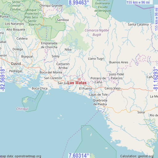
Las Matas GPS coordinates[2]
8° 17' 58.2" North, 81° 51' 57.78" West
| Map corner | latitude | longitude |
|---|---|---|
| Upper-left | 8.99463°, | -82.56918° |
| Center: | 8.2995°, | -81.86605° |
| Lower-right: | 7.60314°, | -81.16293° |
| Map W x H: | 154.7×154.7 km | = 96.1×96.1mi |
| max Lat: | 9.60898° ⇑66.5% North |
| Las Matas: | 8.2995° |
| min Lat: | ⇓33.5% South 7.26534° |
| min Long | Las Matas | max Long |
| -82.91275° | -81.86605° | -77.38965° |
| W 23.3%⇐ | ⇒76.7% E |
Elevation
Elevation of Las Matas is 127 m = 417 ft, and this is 45.1 m = 148 ft below average elevation for this country.
| Max E: |
2103 m = 6900 ft | 34.4% |
| Avg. | 172.1 m = 565 ft | |
| Las Matas | 127 m = 417 ft | |
Min E: |
-1 m = -3 ft | 65.6% |
See also: Panama elevation on elevation.city.
Geographical zone
Las Matas is located in North Torrid zone (between Equator and Tropic of Cancer). Distance of Equator is 922.8 km =573.4 mi to South.| Distance of | km | miles | from Las Matas |
|---|---|---|---|
| North Pole | 9084.2 | 5644.7 | to North |
| Arctic Circle | 6478.4 | 4025.5 | to North |
| Tropic Cancer | 1683.1 | 1045.8 | to North |
| Equator | 922.8 | 573.4 | to South |


Nearby cities:
15 places around Las Matas: (largest is in red/bold)
• Cerro Iglesias
7.6 km =4.7 mi,  101°
101°
• El Porvenir
8.6 km =5.3 mi,  154°
154°
• Hato Jobo
10.5 km =6.5 mi,  347°
347°
• Hato Juli
6.1 km =3.8 mi,  22°
22°
• Juay
9 km =5.6 mi,  259°
259°
• Lajas Adentro
5.7 km =3.5 mi,  193°
193°
• Lajero Arriba
10.6 km =6.6 mi, 95°
• Las Lajas
6.4 km =4 mi,  183°
183°
• Oma
9 km =5.6 mi,  51°
51°
• Quebrada de Loro
9.5 km =5.9 mi,  314°
314°
• Remedios
9.4 km =5.8 mi, 153°
• Salto Dupí
6.2 km =3.9 mi,  338°
338°
• San Félix
1 km =0.6 mi, 186°
• Santa Cruz
9.1 km =5.7 mi,  214°
214°
• Santa Lucia
8.8 km =5.5 mi, 149°
Sources, notices
• [Note1] Compared only with cities in Panama existing in our database
• [Src1] Map data: © OpenStreetMap contributors (CC-BY-SA)
• [Src2] Other city data from geonames.org with taken over terms of usage.
• [Src3] Geographical zone / Annual Mean Temperature by Robert A. Rohde @ Wikipedia
