Lajas Adentro geodata
Lajas Adentro (Chiriquí) is a seat of a third-order administrative division; located in Panama in America/Panama (GMT-5) time zone. With population of 342 people, there are 545 cities with bigger population in this country. Compared to other cities in Panama, 69.4% of cities are located further ↑North; 77.2% of cities are located further →East and 56.8% of cities have higher elevation than Lajas Adentro. Note1


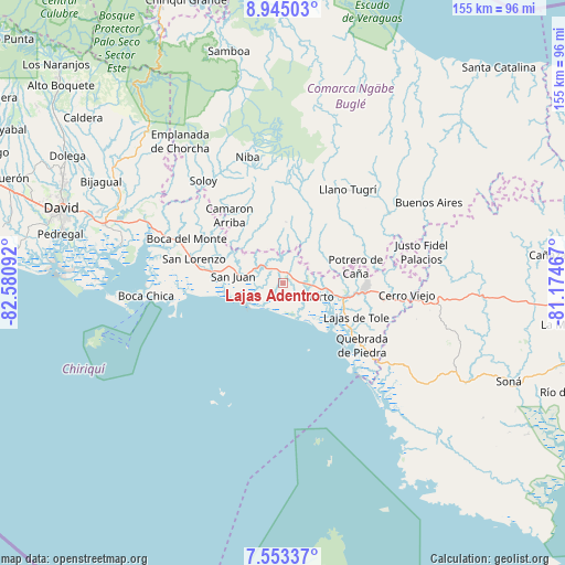
Lajas Adentro GPS coordinates[2]
8° 14' 59.316" North, 81° 52' 40.044" West
| Map corner | latitude | longitude |
|---|---|---|
| Upper-left | 8.94503°, | -82.58092° |
| Center: | 8.24981°, | -81.87779° |
| Lower-right: | 7.55337°, | -81.17467° |
| Map W x H: | 154.7×154.7 km | = 96.1×96.1mi |
| max Lat: | 9.60898° ⇑69.4% North |
| Lajas Adentro: | 8.24981° |
| min Lat: | ⇓30.6% South 7.26534° |
| min Long | Lajas Adentro | max Long |
| -82.91275° | -81.87779° | -77.38965° |
| W 22.8%⇐ | ⇒77.2% E |
Elevation
Elevation of Lajas Adentro is 60 m = 197 ft, and this is 112.1 m = 368 ft below average elevation for this country.
| Max E: |
2103 m = 6900 ft | 56.8% |
| Avg. | 172.1 m = 565 ft | |
| Lajas Adentro | 60 m = 197 ft | |
Min E: |
-1 m = -3 ft | 43.2% |
See also: Panama elevation on elevation.city.
Geographical zone
Lajas Adentro is located in North Torrid zone (between Equator and Tropic of Cancer). Distance of Equator is 917.3 km =570 mi to South.| Distance of | km | miles | from Lajas Adentro |
|---|---|---|---|
| North Pole | 9089.8 | 5648.1 | to North |
| Arctic Circle | 6483.9 | 4028.9 | to North |
| Tropic Cancer | 1688.6 | 1049.2 | to North |
| Equator | 917.3 | 570 | to South |


Nearby cities:
15 places around Lajas Adentro: (largest is in red/bold)
• Cerro Iglesias
9.6 km =6 mi,  65°
65°
• El Porvenir
5.5 km =3.4 mi,  114°
114°
• El Puerto
8.7 km =5.4 mi,  118°
118°
• Hato Juli
11.7 km =7.3 mi,  17°
17°
• Juay
8.5 km =5.3 mi,  296°
296°
• Lajero Arriba
12.6 km =7.8 mi, 68°
• Las Lajas
1.3 km =0.8 mi,  133°
133°
• Las Matas
5.7 km =3.5 mi,  13°
13°
• Pueblito
10.7 km =6.6 mi,  276°
276°
• Remedios
6.2 km =3.9 mi, 117°
• Salto Dupí
11.3 km =7 mi,  355°
355°
• San Félix
4.7 km =2.9 mi, 14°
• San Juan
13.1 km =8.1 mi, 283°
• Santa Cruz
4.4 km =2.7 mi,  243°
243°
• Santa Lucia
6 km =3.7 mi, 109°
Sources, notices
• [Note1] Compared only with cities in Panama existing in our database
• [Src1] Map data: © OpenStreetMap contributors (CC-BY-SA)
• [Src2] Other city data from geonames.org with taken over terms of usage.
• [Src3] Geographical zone / Annual Mean Temperature by Robert A. Rohde @ Wikipedia
