Shupluy geodata
Shupluy (Ancash) is a seat of a third-order administrative division; located in Peru in America/Lima (GMT-5) time zone. In our database, there are 305 cities with bigger population. Compared to other cities in Peru, 67.1% of cities are located further ↓South; 75.9% of cities are located further →East and 58.8% of cities have higher elevation than Shupluy. Note1


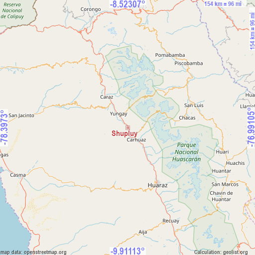
Shupluy GPS coordinates[2]
9° 13' 4.008" South, 77° 41' 39.012" West
| Map corner | latitude | longitude |
|---|---|---|
| Upper-left | -8.52307°, | -78.3973° |
| Center: | -9.21778°, | -77.69417° |
| Lower-right: | -9.91113°, | -76.99105° |
| Map W x H: | 154.3×154.3 km | = 95.9×95.9mi |
| max Lat: | -0.96667° ⇑32.9% North |
| Shupluy: | -9.21778° |
| min Lat: | ⇓67.1% South -18.01465° |
| min Long | Shupluy | max Long |
| -81.30472° | -77.69417° | -69.04167° |
| W 24.1%⇐ | ⇒75.9% E |
Elevation
Elevation of Shupluy is 2497 m = 8192 ft, and this is 178.3 m = 585 ft above average elevation for this country.
| Max E: |
5022 m = 16476 ft | 58.8% |
| Shupluy | 2497 m 8192 ft | |
| Avg. | 2318.7 m = 7607 ft | |
Min E: |
1 m = 3 ft | 41.2% |
See also: Peru elevation on elevation.city.
Geographical zone
Shupluy is located in South Torrid zone (between Equator and Tropic of Capricorn). Distance of Equator is 1024.9 km =636.8 mi to North.| Distance of | km | miles | from Shupluy |
|---|---|---|---|
| Equator | 1024.9 | 636.8 | to North |
| Tropic Capricorn | 1581 | 982.4 | to South |
| Antarctic Circle | 6376.3 | 3962 | to South |
| South Pole | 8982.1 | 5581.2 | to South |


Nearby cities:
15 places around Shupluy: (largest is in red/bold)
• Aco
22.1 km =13.7 mi,  139°
139°
• Acopampa
12.2 km =7.6 mi, 136°
• Amashca
5.8 km =3.6 mi,  114°
114°
• Anta
18.9 km =11.7 mi,  145°
145°
• Carhuac
4.9 km =3 mi,  178°
178°
• Carhuaz
9 km =5.6 mi, 142°
• Cascapara
2.6 km =1.6 mi,  249°
249°
• Mancos
3.6 km =2.2 mi,  324°
324°
• Marcara District
15.3 km =9.5 mi, 139°
• Matacoto
7.5 km =4.7 mi,  306°
306°
• Ranrahirca
6 km =3.7 mi,  329°
329°
• Shilla
7.7 km =4.8 mi,  100°
100°
• Tinco
6 km =3.7 mi,  164°
164°
• Yungar
21 km =13 mi, 148°
• Yungay
10.4 km =6.5 mi, 328°
Sources, notices
• [Note1] Compared only with cities in Peru existing in our database
• [Src1] Map data: © OpenStreetMap contributors (CC-BY-SA)
• [Src2] Other city data from geonames.org with taken over terms of usage.
• [Src3] Geographical zone / Annual Mean Temperature by Robert A. Rohde @ Wikipedia
