Yungay geodata
Yungay (Ancash) is a seat of a third-order administrative division; located in Peru in America/Lima (GMT-5) time zone. With population of 5,269 people, there are 231 cities with bigger population in this country. Compared to other cities in Peru, 68% of cities are located further ↓South; 76.9% of cities are located further →East and 58.3% of cities have higher elevation than Yungay. Note1


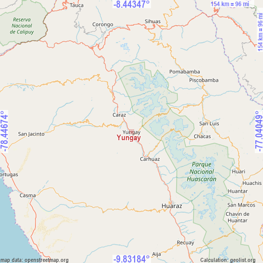
Yungay GPS coordinates[2]
9° 8' 17.988" South, 77° 44' 36.996" West
| Map corner | latitude | longitude |
|---|---|---|
| Upper-left | -8.44347°, | -78.44674° |
| Center: | -9.13833°, | -77.74361° |
| Lower-right: | -9.83184°, | -77.04049° |
| Map W x H: | 154.4×154.4 km | = 95.9×95.9mi |
| max Lat: | -0.96667° ⇑32% North |
| Yungay: | -9.13833° |
| min Lat: | ⇓68% South -18.01465° |
| min Long | Yungay | max Long |
| -81.30472° | -77.74361° | -69.04167° |
| W 23.1%⇐ | ⇒76.9% E |
Elevation
Elevation of Yungay is 2521 m = 8271 ft, and this is 202.3 m = 664 ft above average elevation for this country.
| Max E: |
5022 m = 16476 ft | 58.3% |
| Yungay | 2521 m 8271 ft | |
| Avg. | 2318.7 m = 7607 ft | |
Min E: |
1 m = 3 ft | 41.7% |
See also: Peru elevation on elevation.city.
Geographical zone
Yungay is located in South Torrid zone (between Equator and Tropic of Capricorn). Distance of Equator is 1016.1 km =631.4 mi to North.| Distance of | km | miles | from Yungay |
|---|---|---|---|
| Equator | 1016.1 | 631.4 | to North |
| Tropic Capricorn | 1589.8 | 987.9 | to South |
| Antarctic Circle | 6385.1 | 3967.5 | to South |
| South Pole | 8991 | 5586.7 | to South |


Nearby cities:
15 places around Yungay: (largest is in red/bold)
• Acopampa
22.4 km =13.9 mi,  141°
141°
• Amashca
15.5 km =9.6 mi, 136°
• Carhuac
14.8 km =9.2 mi,  157°
157°
• Carhuaz
19.3 km =12 mi,  145°
145°
• Carás
12.4 km =7.7 mi,  324°
324°
• Cascapara
10.2 km =6.3 mi, 162°
• Huaripampa
23.1 km =14.4 mi,  334°
334°
• Huata
18.7 km =11.6 mi, 316°
• Mancos
6.7 km =4.2 mi, 150°
• Matacoto
4.5 km =2.8 mi,  187°
187°
• Ranrahirca
4.4 km =2.7 mi, 147°
• Shilla
16.6 km =10.3 mi,  128°
128°
• Shupluy
10.4 km =6.5 mi, 148°
• Sucre
24 km =14.9 mi, 330°
• Tinco
16.2 km =10.1 mi, 154°
Sources, notices
• [Note1] Compared only with cities in Peru existing in our database
• [Src1] Map data: © OpenStreetMap contributors (CC-BY-SA)
• [Src2] Other city data from geonames.org with taken over terms of usage.
• [Src3] Geographical zone / Annual Mean Temperature by Robert A. Rohde @ Wikipedia
