Pimentel geodata
Pimentel (Lambayeque) is a seat of a third-order administrative division; located in Peru in America/Lima (GMT-5) time zone. With population of 15,552 people, there are 101 cities with bigger population in this country. Compared to other cities in Peru, 81.4% of cities are located further ↓South; 96.2% of cities are located further →East and 99.5% of cities have higher elevation than Pimentel. Note1


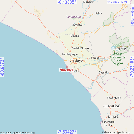
Pimentel GPS coordinates[2]
6° 50' 12.012" South, 79° 56' 3.012" West
| Map corner | latitude | longitude |
|---|---|---|
| Upper-left | -6.13805°, | -80.6373° |
| Center: | -6.83667°, | -79.93417° |
| Lower-right: | -7.53427°, | -79.23105° |
| Map W x H: | 155.2×155.2 km | = 96.4×96.4mi |
| max Lat: | -0.96667° ⇑18.6% North |
| Pimentel: | -6.83667° |
| min Lat: | ⇓81.4% South -18.01465° |
| min Long | Pimentel | max Long |
| -81.30472° | -79.93417° | -69.04167° |
| W 3.8%⇐ | ⇒96.2% E |
Elevation
Elevation of Pimentel is 7 m = 23 ft, and this is 2311.7 m = 7584 ft below average elevation for this country.
| Max E: |
5022 m = 16476 ft | 99.5% |
| Avg. | 2318.7 m = 7607 ft | |
| Pimentel | 7 m = 23 ft | |
Min E: |
1 m = 3 ft | 0.5% |
See also: Peru elevation on elevation.city.
Geographical zone
Pimentel is located in South Torrid zone (between Equator and Tropic of Capricorn). Distance of Equator is 760.2 km =472.4 mi to North.| Distance of | km | miles | from Pimentel |
|---|---|---|---|
| Equator | 760.2 | 472.4 | to North |
| Tropic Capricorn | 1845.8 | 1146.9 | to South |
| Antarctic Circle | 6641 | 4126.5 | to South |
| South Pole | 9246.9 | 5745.8 | to South |


Nearby cities:
15 places around Pimentel: (largest is in red/bold)
• Chiclayo
12.6 km =7.8 mi,  54°
54°
• Eten
11.1 km =6.9 mi,  135°
135°
• Ferreñafe
27.2 km =16.9 mi,  36°
36°
• Lambayeque
15.4 km =9.6 mi,  11°
11°
• Manuel Antonio Mesones Muro
30.5 km =19 mi, 45°
• Mochumí
33.5 km =20.8 mi, 13°
• Monsefú
8.4 km =5.2 mi,  120°
120°
• Mórrope
34.6 km =21.5 mi,  345°
345°
• Picsi
22.5 km =14 mi, 53°
• Pomalca
19 km =11.8 mi,  66°
66°
• Reque
13.2 km =8.2 mi,  104°
104°
• San José
16.1 km =10 mi, 47°
• Santa Rosa
5.2 km =3.2 mi,  162°
162°
• Santa Rosa
14.7 km =9.1 mi, 53°
• Túcume
37.7 km =23.4 mi, 13°
Sources, notices
• [Note1] Compared only with cities in Peru existing in our database
• [Src1] Map data: © OpenStreetMap contributors (CC-BY-SA)
• [Src2] Other city data from geonames.org with taken over terms of usage.
• [Src3] Geographical zone / Annual Mean Temperature by Robert A. Rohde @ Wikipedia
