Monsefú geodata
Monsefú (Lambayeque) is a populated place; located in Peru in America/Lima (GMT-5) time zone. With population of 25,707 people, there are 67 cities with bigger population in this country. Compared to other cities in Peru, 80.9% of cities are located further ↓South; 95.7% of cities are located further →East and 97.8% of cities have higher elevation than Monsefú. Note1


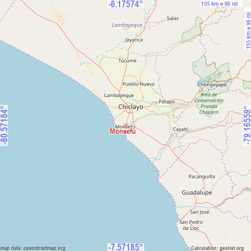
Monsefú GPS coordinates[2]
6° 52' 27.516" South, 79° 52' 7.356" West
| Map corner | latitude | longitude |
|---|---|---|
| Upper-left | -6.17574°, | -80.57184° |
| Center: | -6.87431°, | -79.86871° |
| Lower-right: | -7.57185°, | -79.16559° |
| Map W x H: | 155.2×155.2 km | = 96.4×96.4mi |
| max Lat: | -0.96667° ⇑19.1% North |
| Monsefú: | -6.87431° |
| min Lat: | ⇓80.9% South -18.01465° |
| min Long | Monsefú | max Long |
| -81.30472° | -79.86871° | -69.04167° |
| W 4.3%⇐ | ⇒95.7% E |
Elevation
Elevation of Monsefú is 14 m = 46 ft, and this is 2304.7 m = 7561 ft below average elevation for this country.
| Max E: |
5022 m = 16476 ft | 97.8% |
| Avg. | 2318.7 m = 7607 ft | |
| Monsefú | 14 m = 46 ft | |
Min E: |
1 m = 3 ft | 2.2% |
See also: Peru elevation on elevation.city.
Geographical zone
Monsefú is located in South Torrid zone (between Equator and Tropic of Capricorn). Distance of Equator is 764.4 km =475 mi to North.| Distance of | km | miles | from Monsefú |
|---|---|---|---|
| Equator | 764.4 | 475 | to North |
| Tropic Capricorn | 1841.6 | 1144.3 | to South |
| Antarctic Circle | 6636.8 | 4123.9 | to South |
| South Pole | 9242.7 | 5743.1 | to South |


Nearby cities:
15 places around Monsefú: (largest is in red/bold)
• Chiclayo
11.9 km =7.4 mi,  15°
15°
• Eten
3.8 km =2.4 mi,  172°
172°
• Ferreñafe
27.6 km =17.1 mi, 18°
• Lambayeque
19.7 km =12.2 mi,  347°
347°
• Manuel Antonio Mesones Muro
29.4 km =18.3 mi,  29°
29°
• Mochumí
36.8 km =22.9 mi,  1°
1°
• Mocupe
30.4 km =18.9 mi,  114°
114°
• Picsi
20.6 km =12.8 mi, 32°
• Pimentel
8.4 km =5.2 mi,  300°
300°
• Pomalca
15.6 km =9.7 mi,  40°
40°
• Reque
5.7 km =3.5 mi,  80°
80°
• San José
15.8 km =9.8 mi, 16°
• Santa Rosa
5.7 km =3.5 mi,  262°
262°
• Santa Rosa
13.7 km =8.5 mi, 19°
• Saña
32 km =19.9 mi,  98°
98°
Sources, notices
• [Note1] Compared only with cities in Peru existing in our database
• [Src1] Map data: © OpenStreetMap contributors (CC-BY-SA)
• [Src2] Other city data from geonames.org with taken over terms of usage.
• [Src3] Geographical zone / Annual Mean Temperature by Robert A. Rohde @ Wikipedia
