Ferreñafe geodata
Ferreñafe (Lambayeque) is a seat of a third-order administrative division; located in Peru in America/Lima (GMT-5) time zone. With population of 34,357 people, there are 51 cities with bigger population in this country. Compared to other cities in Peru, 83.1% of cities are located further ↓South; 94.7% of cities are located further →East and 93.3% of cities have higher elevation than Ferreñafe. Note1


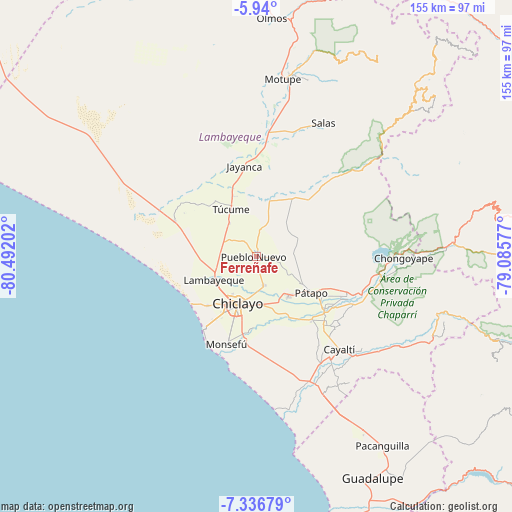
Ferreñafe GPS coordinates[2]
6° 38' 20.004" South, 79° 47' 20.004" West
| Map corner | latitude | longitude |
|---|---|---|
| Upper-left | -5.94°, | -80.49202° |
| Center: | -6.63889°, | -79.78889° |
| Lower-right: | -7.33679°, | -79.08577° |
| Map W x H: | 155.3×155.3 km | = 96.5×96.5mi |
| max Lat: | -0.96667° ⇑16.9% North |
| Ferreñafe: | -6.63889° |
| min Lat: | ⇓83.1% South -18.01465° |
| min Long | Ferreñafe | max Long |
| -81.30472° | -79.78889° | -69.04167° |
| W 5.3%⇐ | ⇒94.7% E |
Elevation
Elevation of Ferreñafe is 42 m = 138 ft, and this is 2276.7 m = 7469 ft below average elevation for this country.
| Max E: |
5022 m = 16476 ft | 93.3% |
| Avg. | 2318.7 m = 7607 ft | |
| Ferreñafe | 42 m = 138 ft | |
Min E: |
1 m = 3 ft | 6.7% |
See also: Peru elevation on elevation.city.
Geographical zone
Ferreñafe is located in South Torrid zone (between Equator and Tropic of Capricorn). Distance of Equator is 738.2 km =458.7 mi to North.| Distance of | km | miles | from Ferreñafe |
|---|---|---|---|
| Equator | 738.2 | 458.7 | to North |
| Tropic Capricorn | 1867.7 | 1160.5 | to South |
| Antarctic Circle | 6663 | 4140.2 | to South |
| South Pole | 9268.9 | 5759.4 | to South |


Nearby cities:
15 places around Ferreñafe: (largest is in red/bold)
• Chiclayo
15.8 km =9.8 mi,  201°
201°
• Jayanca
27.8 km =17.3 mi,  352°
352°
• Lambayeque
14.7 km =9.1 mi,  241°
241°
• Manuel Antonio Mesones Muro
5.6 km =3.5 mi,  95°
95°
• Mochumí
13.3 km =8.3 mi,  322°
322°
• Monsefú
27.6 km =17.1 mi, 198°
• Mórrope
27.1 km =16.8 mi,  295°
295°
• Pacora
24 km =14.9 mi, 346°
• Picsi
9 km =5.6 mi,  166°
166°
• Pimentel
27.2 km =16.9 mi,  216°
216°
• Pomalca
14.4 km =8.9 mi, 174°
• Reque
25.4 km =15.8 mi,  187°
187°
• San José
11.8 km =7.3 mi, 201°
• Santa Rosa
13.9 km =8.6 mi, 197°
• Túcume
16.6 km =10.3 mi,  332°
332°
Sources, notices
• [Note1] Compared only with cities in Peru existing in our database
• [Src1] Map data: © OpenStreetMap contributors (CC-BY-SA)
• [Src2] Other city data from geonames.org with taken over terms of usage.
• [Src3] Geographical zone / Annual Mean Temperature by Robert A. Rohde @ Wikipedia
