Macate geodata
Macate (Ancash) is a seat of a third-order administrative division; located in Peru in America/Lima (GMT-5) time zone. In our database, there are 305 cities with bigger population. Compared to other cities in Peru, 70% of cities are located further ↓South; 82.6% of cities are located further →East and 64.1% of cities have higher elevation than Macate. Note1


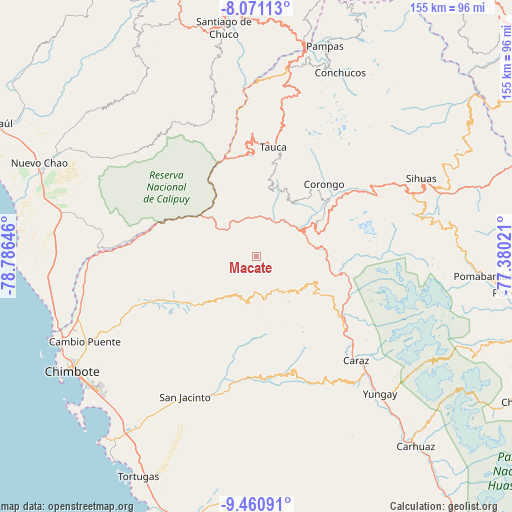
Macate GPS coordinates[2]
8° 46' 0.012" South, 78° 4' 59.988" West
| Map corner | latitude | longitude |
|---|---|---|
| Upper-left | -8.07113°, | -78.78646° |
| Center: | -8.76667°, | -78.08333° |
| Lower-right: | -9.46091°, | -77.38021° |
| Map W x H: | 154.5×154.5 km | = 96×96mi |
| max Lat: | -0.96667° ⇑30% North |
| Macate: | -8.76667° |
| min Lat: | ⇓70% South -18.01465° |
| min Long | Macate | max Long |
| -81.30472° | -78.08333° | -69.04167° |
| W 17.4%⇐ | ⇒82.6% E |
Elevation
Elevation of Macate is 2127 m = 6978 ft, and this is 191.7 m = 629 ft below average elevation for this country.
| Max E: |
5022 m = 16476 ft | 64.1% |
| Avg. | 2318.7 m = 7607 ft | |
| Macate | 2127 m = 6978 ft | |
Min E: |
1 m = 3 ft | 35.9% |
See also: Peru elevation on elevation.city.
Geographical zone
Macate is located in South Torrid zone (between Equator and Tropic of Capricorn). Distance of Equator is 974.8 km =605.7 mi to North.| Distance of | km | miles | from Macate |
|---|---|---|---|
| Equator | 974.8 | 605.7 | to North |
| Tropic Capricorn | 1631.2 | 1013.6 | to South |
| Antarctic Circle | 6426.4 | 3993.2 | to South |
| South Pole | 9032.3 | 5612.4 | to South |


Nearby cities:
15 places around Macate: (largest is in red/bold)
• Aco
34 km =21.1 mi,  40°
40°
• Bambas
20.7 km =12.9 mi,  26°
26°
• Bolognesi
46.4 km =28.8 mi,  2°
2°
• Cabana
41.1 km =25.5 mi,  7°
7°
• Carás
43.3 km =26.9 mi,  135°
135°
• Corongo
27.4 km =17 mi, 41°
• Huallanca
24.4 km =15.2 mi,  103°
103°
• Huaripampa
34.2 km =21.3 mi,  126°
126°
• Huata
37 km =23 mi, 138°
• La Pampa
24 km =14.9 mi,  57°
57°
• Moro
42.8 km =26.6 mi,  194°
194°
• Pamparomas
35.9 km =22.3 mi,  161°
161°
• Sucre
32.8 km =20.4 mi, 128°
• Tauca
31.7 km =19.7 mi, 6°
• Yanac
29.1 km =18.1 mi,  54°
54°
Sources, notices
• [Note1] Compared only with cities in Peru existing in our database
• [Src1] Map data: © OpenStreetMap contributors (CC-BY-SA)
• [Src2] Other city data from geonames.org with taken over terms of usage.
• [Src3] Geographical zone / Annual Mean Temperature by Robert A. Rohde @ Wikipedia
