Huaripampa geodata
Huaripampa (Ancash) is a seat of a third-order administrative division; located in Peru in America/Lima (GMT-5) time zone. In our database, there are 305 cities with bigger population. Compared to other cities in Peru, 69.3% of cities are located further ↓South; 78.2% of cities are located further →East and 63.4% of cities have higher elevation than Huaripampa. Note1


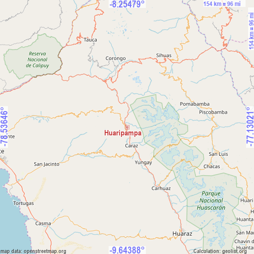
Huaripampa GPS coordinates[2]
8° 57' 0" South, 77° 49' 59.988" West
| Map corner | latitude | longitude |
|---|---|---|
| Upper-left | -8.25479°, | -78.53646° |
| Center: | -8.95°, | -77.83333° |
| Lower-right: | -9.64388°, | -77.13021° |
| Map W x H: | 154.5×154.5 km | = 96×96mi |
| max Lat: | -0.96667° ⇑30.7% North |
| Huaripampa: | -8.95° |
| min Lat: | ⇓69.3% South -18.01465° |
| min Long | Huaripampa | max Long |
| -81.30472° | -77.83333° | -69.04167° |
| W 21.8%⇐ | ⇒78.2% E |
Elevation
Elevation of Huaripampa is 2197 m = 7208 ft, and this is 121.7 m = 399 ft below average elevation for this country.
| Max E: |
5022 m = 16476 ft | 63.4% |
| Avg. | 2318.7 m = 7607 ft | |
| Huaripampa | 2197 m = 7208 ft | |
Min E: |
1 m = 3 ft | 36.6% |
See also: Peru elevation on elevation.city.
Geographical zone
Huaripampa is located in South Torrid zone (between Equator and Tropic of Capricorn). Distance of Equator is 995.1 km =618.3 mi to North.| Distance of | km | miles | from Huaripampa |
|---|---|---|---|
| Equator | 995.1 | 618.3 | to North |
| Tropic Capricorn | 1610.8 | 1000.9 | to South |
| Antarctic Circle | 6406 | 3980.5 | to South |
| South Pole | 9011.9 | 5599.7 | to South |


Nearby cities:
15 places around Huaripampa: (largest is in red/bold)
• Carhuac
37.9 km =23.5 mi,  155°
155°
• Carás
11.1 km =6.9 mi,  166°
166°
• Cascapara
33.2 km =20.6 mi, 157°
• Huallanca
15.3 km =9.5 mi,  346°
346°
• Huata
7.9 km =4.9 mi,  202°
202°
• La Pampa
34.2 km =21.3 mi, 347°
• Macate
34.2 km =21.3 mi,  306°
306°
• Mancos
29.9 km =18.6 mi,  153°
153°
• Matacoto
27 km =16.8 mi, 159°
• Pamparomas
21.3 km =13.2 mi,  229°
229°
• Ranrahirca
27.5 km =17.1 mi, 153°
• Shupluy
33.5 km =20.8 mi, 152°
• Sucre
1.8 km =1.1 mi,  270°
270°
• Yanac
37.2 km =23.1 mi, 354°
• Yungay
23.1 km =14.4 mi, 154°
Sources, notices
• [Note1] Compared only with cities in Peru existing in our database
• [Src1] Map data: © OpenStreetMap contributors (CC-BY-SA)
• [Src2] Other city data from geonames.org with taken over terms of usage.
• [Src3] Geographical zone / Annual Mean Temperature by Robert A. Rohde @ Wikipedia
