Carás geodata
Carás (Ancash) is a populated place; located in Peru in America/Lima (GMT-5) time zone. With population of 10,926 people, there are 136 cities with bigger population in this country. Compared to other cities in Peru, 68.6% of cities are located further ↓South; 77.7% of cities are located further →East and 62.6% of cities have higher elevation than Carás. Note1


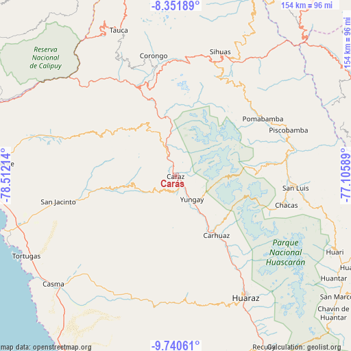
Carás GPS coordinates[2]
9° 2' 48.912" South, 77° 48' 32.436" West
| Map corner | latitude | longitude |
|---|---|---|
| Upper-left | -8.35189°, | -78.51214° |
| Center: | -9.04692°, | -77.80901° |
| Lower-right: | -9.74061°, | -77.10589° |
| Map W x H: | 154.4×154.4 km | = 95.9×95.9mi |
| max Lat: | -0.96667° ⇑31.4% North |
| Carás: | -9.04692° |
| min Lat: | ⇓68.6% South -18.01465° |
| min Long | Carás | max Long |
| -81.30472° | -77.80901° | -69.04167° |
| W 22.3%⇐ | ⇒77.7% E |
Elevation
Elevation of Carás is 2275 m = 7464 ft, and this is 43.7 m = 143 ft below average elevation for this country.
| Max E: |
5022 m = 16476 ft | 62.6% |
| Avg. | 2318.7 m = 7607 ft | |
| Carás | 2275 m = 7464 ft | |
Min E: |
1 m = 3 ft | 37.4% |
See also: Peru elevation on elevation.city.
Geographical zone
Carás is located in South Torrid zone (between Equator and Tropic of Capricorn). Distance of Equator is 1005.9 km =625 mi to North.| Distance of | km | miles | from Carás |
|---|---|---|---|
| Equator | 1005.9 | 625 | to North |
| Tropic Capricorn | 1600 | 994.2 | to South |
| Antarctic Circle | 6395.3 | 3973.9 | to South |
| South Pole | 9001.1 | 5593 | to South |


Nearby cities:
15 places around Carás: (largest is in red/bold)
• Amashca
27.9 km =17.3 mi,  140°
140°
• Carhuac
27.1 km =16.8 mi,  151°
151°
• Cascapara
22.3 km =13.9 mi, 152°
• Huallanca
26.4 km =16.4 mi,  346°
346°
• Huaripampa
11.1 km =6.9 mi, 346°
• Huata
6.6 km =4.1 mi,  301°
301°
• Mancos
19.2 km =11.9 mi, 146°
• Matacoto
16 km =9.9 mi,  155°
155°
• Pamparomas
19.2 km =11.9 mi,  261°
261°
• Ranrahirca
16.8 km =10.4 mi, 145°
• Shilla
28.7 km =17.8 mi, 135°
• Shupluy
22.8 km =14.2 mi, 146°
• Sucre
11.7 km =7.3 mi,  337°
337°
• Tinco
28.6 km =17.8 mi, 150°
• Yungay
12.4 km =7.7 mi, 144°
Sources, notices
• [Note1] Compared only with cities in Peru existing in our database
• [Src1] Map data: © OpenStreetMap contributors (CC-BY-SA)
• [Src2] Other city data from geonames.org with taken over terms of usage.
• [Src3] Geographical zone / Annual Mean Temperature by Robert A. Rohde @ Wikipedia
