Colasay geodata
Colasay (Cajamarca) is a seat of a third-order administrative division; located in Peru in America/Lima (GMT-5) time zone. In our database, there are 305 cities with bigger population. Compared to other cities in Peru, 90.4% of cities are located further ↓South; 90.7% of cities are located further →East and 67.6% of cities have higher elevation than Colasay. Note1


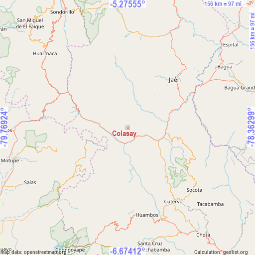
Colasay GPS coordinates[2]
5° 58' 31.008" South, 79° 3' 57.996" West
| Map corner | latitude | longitude |
|---|---|---|
| Upper-left | -5.27555°, | -79.76924° |
| Center: | -5.97528°, | -79.06611° |
| Lower-right: | -6.67412°, | -78.36299° |
| Map W x H: | 155.5×155.5 km | = 96.6×96.6mi |
| max Lat: | -0.96667° ⇑9.6% North |
| Colasay: | -5.97528° |
| min Lat: | ⇓90.4% South -18.01465° |
| min Long | Colasay | max Long |
| -81.30472° | -79.06611° | -69.04167° |
| W 9.3%⇐ | ⇒90.7% E |
Elevation
Elevation of Colasay is 1821 m = 5974 ft, and this is 497.7 m = 1633 ft below average elevation for this country.
| Max E: |
5022 m = 16476 ft | 67.6% |
| Avg. | 2318.7 m = 7607 ft | |
| Colasay | 1821 m = 5974 ft | |
Min E: |
1 m = 3 ft | 32.4% |
See also: Peru elevation on elevation.city.
Geographical zone
Colasay is located in South Torrid zone (between Equator and Tropic of Capricorn). Distance of Equator is 664.4 km =412.8 mi to North.| Distance of | km | miles | from Colasay |
|---|---|---|---|
| Equator | 664.4 | 412.8 | to North |
| Tropic Capricorn | 1941.5 | 1206.4 | to South |
| Antarctic Circle | 6736.8 | 4186.1 | to South |
| South Pole | 9342.7 | 5805.3 | to South |


Nearby cities:
15 places around Colasay: (largest is in red/bold)
• Cañaris
23.3 km =14.5 mi,  250°
250°
• Choros
41.9 km =26 mi,  78°
78°
• Cumba
44.9 km =27.9 mi, 83°
• Cutervo
49.6 km =30.8 mi,  151°
151°
• Huabal
42.9 km =26.7 mi,  21°
21°
• Incahuasi
40.1 km =24.9 mi,  223°
223°
• Jaén
41.3 km =25.7 mi,  43°
43°
• La Sacilia
37.6 km =23.4 mi,  85°
85°
• Las Pirias
45.3 km =28.1 mi,  31°
31°
• Pomahuaca
18.4 km =11.4 mi,  286°
286°
• Querocotillo
33.3 km =20.7 mi,  174°
174°
• Querocoto
42.8 km =26.6 mi,  175°
175°
• Sallique
44.9 km =27.9 mi,  322°
322°
• San Felipe
35.6 km =22.1 mi,  310°
310°
• Socota
51.5 km =32 mi,  134°
134°
Sources, notices
• [Note1] Compared only with cities in Peru existing in our database
• [Src1] Map data: © OpenStreetMap contributors (CC-BY-SA)
• [Src2] Other city data from geonames.org with taken over terms of usage.
• [Src3] Geographical zone / Annual Mean Temperature by Robert A. Rohde @ Wikipedia
