Pomahuaca geodata
Pomahuaca (Cajamarca) is a seat of a third-order administrative division; located in Peru in America/Lima (GMT-5) time zone. In our database, there are 305 cities with bigger population. Compared to other cities in Peru, 90.9% of cities are located further ↓South; 91.6% of cities are located further →East and 71.5% of cities have higher elevation than Pomahuaca. Note1


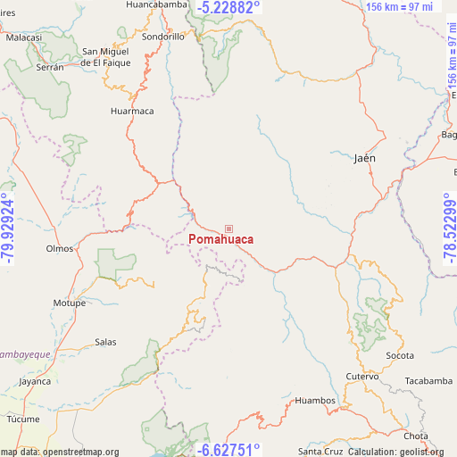
Pomahuaca GPS coordinates[2]
5° 55' 42.996" South, 79° 13' 33.996" West
| Map corner | latitude | longitude |
|---|---|---|
| Upper-left | -5.22882°, | -79.92924° |
| Center: | -5.92861°, | -79.22611° |
| Lower-right: | -6.62751°, | -78.52299° |
| Map W x H: | 155.5×155.5 km | = 96.6×96.6mi |
| max Lat: | -0.96667° ⇑9.1% North |
| Pomahuaca: | -5.92861° |
| min Lat: | ⇓90.9% South -18.01465° |
| min Long | Pomahuaca | max Long |
| -81.30472° | -79.22611° | -69.04167° |
| W 8.4%⇐ | ⇒91.6% E |
Elevation
Elevation of Pomahuaca is 1142 m = 3747 ft, and this is 1176.7 m = 3861 ft below average elevation for this country.
| Max E: |
5022 m = 16476 ft | 71.5% |
| Avg. | 2318.7 m = 7607 ft | |
| Pomahuaca | 1142 m = 3747 ft | |
Min E: |
1 m = 3 ft | 28.5% |
See also: Peru elevation on elevation.city.
Geographical zone
Pomahuaca is located in South Torrid zone (between Equator and Tropic of Capricorn). Distance of Equator is 659.2 km =409.6 mi to North.| Distance of | km | miles | from Pomahuaca |
|---|---|---|---|
| Equator | 659.2 | 409.6 | to North |
| Tropic Capricorn | 1946.7 | 1209.6 | to South |
| Antarctic Circle | 6742 | 4189.3 | to South |
| South Pole | 9347.9 | 5808.5 | to South |


Nearby cities:
15 places around Pomahuaca: (largest is in red/bold)
• Cañaris
13.7 km =8.5 mi,  198°
198°
• Colasay
18.4 km =11.4 mi,  106°
106°
• Huabal
48.3 km =30 mi,  43°
43°
• Huarmaca
51.9 km =32.2 mi,  320°
320°
• Incahuasi
35.6 km =22.1 mi, 196°
• Jaén
52.4 km =32.6 mi,  61°
61°
• La Sacilia
55.2 km =34.3 mi,  92°
92°
• Las Pirias
53.2 km =33.1 mi,  50°
50°
• Licupis
55.2 km =34.3 mi,  181°
181°
• Miracosta
53.3 km =33.1 mi,  186°
186°
• Querocotillo
43.7 km =27.2 mi,  151°
151°
• Querocoto
52.3 km =32.5 mi,  156°
156°
• Sallique
31.9 km =19.8 mi,  342°
342°
• San Felipe
20.2 km =12.6 mi,  332°
332°
• Tocmoche
55.9 km =34.7 mi, 195°
Sources, notices
• [Note1] Compared only with cities in Peru existing in our database
• [Src1] Map data: © OpenStreetMap contributors (CC-BY-SA)
• [Src2] Other city data from geonames.org with taken over terms of usage.
• [Src3] Geographical zone / Annual Mean Temperature by Robert A. Rohde @ Wikipedia
