Incahuasi geodata
Incahuasi (Lambayeque) is a seat of a third-order administrative division; located in Peru in America/Lima (GMT-5) time zone. In our database, there are 305 cities with bigger population. Compared to other cities in Peru, 88% of cities are located further ↓South; 92.5% of cities are located further →East and 55% of cities have lower elevation than Incahuasi. Note1


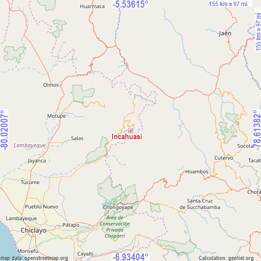
Incahuasi GPS coordinates[2]
6° 14' 8.016" South, 79° 19' 0.984" West
| Map corner | latitude | longitude |
|---|---|---|
| Upper-left | -5.53615°, | -80.02007° |
| Center: | -6.23556°, | -79.31694° |
| Lower-right: | -6.93404°, | -78.61382° |
| Map W x H: | 155.4×155.4 km | = 96.6×96.6mi |
| max Lat: | -0.96667° ⇑12% North |
| Incahuasi: | -6.23556° |
| min Lat: | ⇓88% South -18.01465° |
| min Long | Incahuasi | max Long |
| -81.30472° | -79.31694° | -69.04167° |
| W 7.5%⇐ | ⇒92.5% E |
Elevation
Elevation of Incahuasi is 3022 m = 9915 ft, and this is 703.3 m = 2307 ft above average elevation for this country.
| Max E: |
5022 m = 16476 ft | 45% |
| Incahuasi | 3022 m 9915 ft | |
| Avg. | 2318.7 m = 7607 ft | |
Min E: |
1 m = 3 ft | 55% |
See also: Peru elevation on elevation.city.
Geographical zone
Incahuasi is located in South Torrid zone (between Equator and Tropic of Capricorn). Distance of Equator is 693.3 km =430.8 mi to North.| Distance of | km | miles | from Incahuasi |
|---|---|---|---|
| Equator | 693.3 | 430.8 | to North |
| Tropic Capricorn | 1912.6 | 1188.4 | to South |
| Antarctic Circle | 6707.8 | 4168 | to South |
| South Pole | 9313.7 | 5787.3 | to South |


Nearby cities:
15 places around Incahuasi: (largest is in red/bold)
• Cañaris
21.8 km =13.5 mi,  15°
15°
• Chongoyape
45.7 km =28.4 mi,  190°
190°
• Colasay
40.1 km =24.9 mi,  43°
43°
• Huambos
46.5 km =28.9 mi,  123°
123°
• Licupis
22.6 km =14 mi,  158°
158°
• Llama
37.9 km =23.5 mi,  144°
144°
• Miracosta
19.1 km =11.9 mi,  169°
169°
• Motupe
44.9 km =27.9 mi,  281°
281°
• Pomahuaca
35.6 km =22.1 mi, 16°
• Querocotillo
31.1 km =19.3 mi,  97°
97°
• Querocoto
34 km =21.1 mi,  113°
113°
• Salas
32 km =19.9 mi,  262°
262°
• San Felipe
52 km =32.3 mi,  0°
0°
• Sexi
46.8 km =29.1 mi, 141°
• Tocmoche
20.3 km =12.6 mi, 194°
Sources, notices
• [Note1] Compared only with cities in Peru existing in our database
• [Src1] Map data: © OpenStreetMap contributors (CC-BY-SA)
• [Src2] Other city data from geonames.org with taken over terms of usage.
• [Src3] Geographical zone / Annual Mean Temperature by Robert A. Rohde @ Wikipedia
