Chillia geodata
Chillia (La Libertad) is a seat of a third-order administrative division; located in Peru in America/Lima (GMT-5) time zone. In our database, there are 305 cities with bigger population. Compared to other cities in Peru, 73.4% of cities are located further ↓South; 72.8% of cities are located further →East and 96% of cities have lower elevation than Chillia. Note1


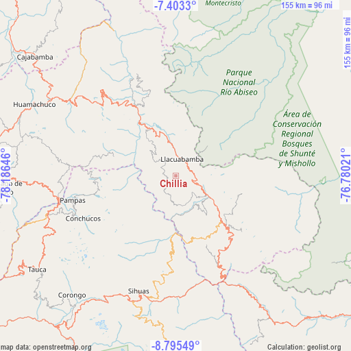
Chillia GPS coordinates[2]
8° 6' 0" South, 77° 28' 59.988" West
| Map corner | latitude | longitude |
|---|---|---|
| Upper-left | -7.4033°, | -78.18646° |
| Center: | -8.1°, | -77.48333° |
| Lower-right: | -8.79549°, | -76.78021° |
| Map W x H: | 154.8×154.8 km | = 96.2×96.2mi |
| max Lat: | -0.96667° ⇑26.6% North |
| Chillia: | -8.1° |
| min Lat: | ⇓73.4% South -18.01465° |
| min Long | Chillia | max Long |
| -81.30472° | -77.48333° | -69.04167° |
| W 27.2%⇐ | ⇒72.8% E |
Elevation
Elevation of Chillia is 4114 m = 13497 ft, and this is 1795.3 m = 5890 ft above average elevation for this country.
| Max E: |
5022 m = 16476 ft | 4% |
| Chillia | 4114 m 13497 ft | |
| Avg. | 2318.7 m = 7607 ft | |
Min E: |
1 m = 3 ft | 96% |
See also: Peru elevation on elevation.city.
Geographical zone
Chillia is located in South Torrid zone (between Equator and Tropic of Capricorn). Distance of Equator is 900.6 km =559.6 mi to North.| Distance of | km | miles | from Chillia |
|---|---|---|---|
| Equator | 900.6 | 559.6 | to North |
| Tropic Capricorn | 1705.3 | 1059.6 | to South |
| Antarctic Circle | 6500.5 | 4039.2 | to South |
| South Pole | 9106.4 | 5658.5 | to South |


Nearby cities:
15 places around Chillia: (largest is in red/bold)
• Aricapampa
41.6 km =25.8 mi,  321°
321°
• Challas
41.7 km =25.9 mi,  154°
154°
• Conchucos
44.4 km =27.6 mi,  245°
245°
• Huancaspata
44.6 km =27.7 mi, 152°
• Huaylillas
18.3 km =11.4 mi,  122°
122°
• Lacabamba
49.5 km =30.8 mi, 247°
• Mollepata
52.6 km =32.7 mi,  257°
257°
• Pampas
47.2 km =29.3 mi, 256°
• Parcoy
7.4 km =4.6 mi,  3°
3°
• Quiches
32.8 km =20.4 mi,  181°
181°
• Sitabamba
28.5 km =17.7 mi,  285°
285°
• Taurija
24.2 km =15 mi,  163°
163°
• Tayabamba
28.5 km =17.7 mi,  133°
133°
• Ullulluco
40 km =24.9 mi,  171°
171°
• Urpay
29.4 km =18.3 mi, 159°
Sources, notices
• [Note1] Compared only with cities in Peru existing in our database
• [Src1] Map data: © OpenStreetMap contributors (CC-BY-SA)
• [Src2] Other city data from geonames.org with taken over terms of usage.
• [Src3] Geographical zone / Annual Mean Temperature by Robert A. Rohde @ Wikipedia
