Parcoy geodata
Parcoy (La Libertad) is a seat of a third-order administrative division; located in Peru in America/Lima (GMT-5) time zone. In our database, there are 305 cities with bigger population. Compared to other cities in Peru, 73.8% of cities are located further ↓South; 72.5% of cities are located further →East and 59.7% of cities have lower elevation than Parcoy. Note1


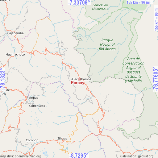
Parcoy GPS coordinates[2]
8° 2' 2.004" South, 77° 28' 45.012" West
| Map corner | latitude | longitude |
|---|---|---|
| Upper-left | -7.33709°, | -78.1823° |
| Center: | -8.03389°, | -77.47917° |
| Lower-right: | -8.7295°, | -76.77605° |
| Map W x H: | 154.8×154.8 km | = 96.2×96.2mi |
| max Lat: | -0.96667° ⇑26.2% North |
| Parcoy: | -8.03389° |
| min Lat: | ⇓73.8% South -18.01465° |
| min Long | Parcoy | max Long |
| -81.30472° | -77.47917° | -69.04167° |
| W 27.5%⇐ | ⇒72.5% E |
Elevation
Elevation of Parcoy is 3140 m = 10302 ft, and this is 821.3 m = 2695 ft above average elevation for this country.
| Max E: |
5022 m = 16476 ft | 40.3% |
| Parcoy | 3140 m 10302 ft | |
| Avg. | 2318.7 m = 7607 ft | |
Min E: |
1 m = 3 ft | 59.7% |
See also: Peru elevation on elevation.city.
Geographical zone
Parcoy is located in South Torrid zone (between Equator and Tropic of Capricorn). Distance of Equator is 893.3 km =555.1 mi to North.| Distance of | km | miles | from Parcoy |
|---|---|---|---|
| Equator | 893.3 | 555.1 | to North |
| Tropic Capricorn | 1712.6 | 1064.2 | to South |
| Antarctic Circle | 6507.9 | 4043.8 | to South |
| South Pole | 9113.8 | 5663.1 | to South |


Nearby cities:
15 places around Parcoy: (largest is in red/bold)
• Aricapampa
36.5 km =22.7 mi,  314°
314°
• Challas
48.2 km =30 mi,  158°
158°
• Chillia
7.4 km =4.6 mi,  183°
183°
• Chugay
51.2 km =31.8 mi,  303°
303°
• Conchucos
48.3 km =30 mi,  237°
237°
• Huancaspata
51 km =31.7 mi, 157°
• Huaylillas
22.7 km =14.1 mi,  138°
138°
• Pampas
49.9 km =31 mi,  248°
248°
• Quiches
40.2 km =25 mi, 181°
• Sartimbamba
47.3 km =29.4 mi,  321°
321°
• Sitabamba
28 km =17.4 mi,  270°
270°
• Taurija
31.2 km =19.4 mi,  168°
168°
• Tayabamba
33.7 km =20.9 mi, 143°
• Ullulluco
47.2 km =29.3 mi, 172°
• Urpay
36.2 km =22.5 mi, 164°
Sources, notices
• [Note1] Compared only with cities in Peru existing in our database
• [Src1] Map data: © OpenStreetMap contributors (CC-BY-SA)
• [Src2] Other city data from geonames.org with taken over terms of usage.
• [Src3] Geographical zone / Annual Mean Temperature by Robert A. Rohde @ Wikipedia
