Cahuac geodata
Cahuac (Huanuco) is a seat of a third-order administrative division; located in Peru in America/Lima (GMT-5) time zone. In our database, there are 305 cities with bigger population. Compared to other cities in Peru, 62.1% of cities are located further ↓South; 61% of cities are located further →East and 71.4% of cities have lower elevation than Cahuac. Note1


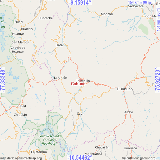
Cahuac GPS coordinates[2]
9° 51' 9.396" South, 76° 37' 49.26" West
| Map corner | latitude | longitude |
|---|---|---|
| Upper-left | -9.15914°, | -77.33348° |
| Center: | -9.85261°, | -76.63035° |
| Lower-right: | -10.54462°, | -75.92723° |
| Map W x H: | 154.1×154.1 km | = 95.8×95.8mi |
| max Lat: | -0.96667° ⇑37.9% North |
| Cahuac: | -9.85261° |
| min Lat: | ⇓62.1% South -18.01465° |
| min Long | Cahuac | max Long |
| -81.30472° | -76.63035° | -69.04167° |
| W 39%⇐ | ⇒61% E |
Elevation
Elevation of Cahuac is 3374 m = 11070 ft, and this is 1055.3 m = 3462 ft above average elevation for this country.
| Max E: |
5022 m = 16476 ft | 28.6% |
| Cahuac | 3374 m 11070 ft | |
| Avg. | 2318.7 m = 7607 ft | |
Min E: |
1 m = 3 ft | 71.4% |
See also: Peru elevation on elevation.city.
Geographical zone
Cahuac is located in South Torrid zone (between Equator and Tropic of Capricorn). Distance of Equator is 1095.5 km =680.7 mi to North.| Distance of | km | miles | from Cahuac |
|---|---|---|---|
| Equator | 1095.5 | 680.7 | to North |
| Tropic Capricorn | 1510.4 | 938.5 | to South |
| Antarctic Circle | 6305.7 | 3918.2 | to South |
| South Pole | 8911.6 | 5537.4 | to South |


Nearby cities:
15 places around Cahuac: (largest is in red/bold)
• Baños
27.4 km =17 mi,  204°
204°
• Chavinillo
2.5 km =1.6 mi,  105°
105°
• Chuquis
21.2 km =13.2 mi,  337°
337°
• Huancapallac
24.1 km =15 mi,  101°
101°
• Jivia
19.8 km =12.3 mi, 195°
• La Unión
19 km =11.8 mi,  278°
278°
• Margos
20.8 km =12.9 mi,  145°
145°
• Obas
7.4 km =4.6 mi,  328°
328°
• Pachas
22.4 km =13.9 mi,  316°
316°
• Pampamarca
18.1 km =11.2 mi, 334°
• Quivilla
30 km =18.6 mi, 339°
• Rondos
15.9 km =9.9 mi, 203°
• Shunqui
21.6 km =13.4 mi,  307°
307°
• Sillapata
19 km =11.8 mi,  303°
303°
• Yanas
20.1 km =12.5 mi, 320°
Sources, notices
• [Note1] Compared only with cities in Peru existing in our database
• [Src1] Map data: © OpenStreetMap contributors (CC-BY-SA)
• [Src2] Other city data from geonames.org with taken over terms of usage.
• [Src3] Geographical zone / Annual Mean Temperature by Robert A. Rohde @ Wikipedia
