Margos geodata
Margos (Huanuco) is a seat of a third-order administrative division; located in Peru in America/Lima (GMT-5) time zone. In our database, there are 305 cities with bigger population. Compared to other cities in Peru, 61.1% of cities are located further ↓South; 59.7% of cities are located further →East and 80.5% of cities have lower elevation than Margos. Note1


Margos GPS coordinates[2]
10° 0' 21.996" South, 76° 31' 21" West
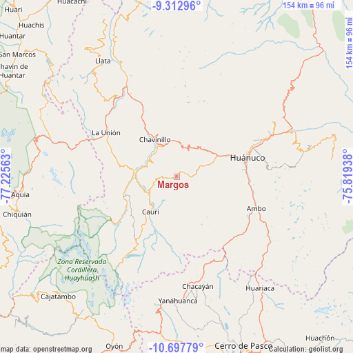
| Map corner | latitude | longitude |
|---|---|---|
| Upper-left | -9.31296°, | -77.22563° |
| Center: | -10.00611°, | -76.5225° |
| Lower-right: | -10.69779°, | -75.81938° |
| Map W x H: | 154×154 km | = 95.7×95.7mi |
| max Lat: | -0.96667° ⇑38.9% North |
| Margos: | -10.00611° |
| min Lat: | ⇓61.1% South -18.01465° |
| min Long | Margos | max Long |
| -81.30472° | -76.5225° | -69.04167° |
| W 40.3%⇐ | ⇒59.7% E |
Elevation
Elevation of Margos is 3541 m = 11617 ft, and this is 1222.3 m = 4010 ft above average elevation for this country.
| Max E: |
5022 m = 16476 ft | 19.5% |
| Margos | 3541 m 11617 ft | |
| Avg. | 2318.7 m = 7607 ft | |
Min E: |
1 m = 3 ft | 80.5% |
See also: Peru elevation on elevation.city.
Geographical zone
Margos is located in South Torrid zone (between Equator and Tropic of Capricorn). Distance of Equator is 1112.6 km =691.3 mi to North.| Distance of | km | miles | from Margos |
|---|---|---|---|
| Equator | 1112.6 | 691.3 | to North |
| Tropic Capricorn | 1493.3 | 927.9 | to South |
| Antarctic Circle | 6288.6 | 3907.6 | to South |
| South Pole | 8894.5 | 5526.8 | to South |


Nearby cities:
15 places around Margos: (largest is in red/bold)
• Baños
24.6 km =15.3 mi,  251°
251°
• Cahuac
20.8 km =12.9 mi,  325°
325°
• Cauri
18.8 km =11.7 mi,  216°
216°
• Cayhuayna
30.5 km =19 mi,  79°
79°
• Cayna
33 km =20.5 mi,  153°
153°
• Chavinillo
18.9 km =11.7 mi, 330°
• Colpas
31.5 km =19.6 mi,  157°
157°
• Huancapallac
17.2 km =10.7 mi,  43°
43°
• Huánuco
31.8 km =19.8 mi,  74°
74°
• Jivia
17.3 km =10.7 mi,  263°
263°
• Obas
28.2 km =17.5 mi, 326°
• Paucarbamba
33.5 km =20.8 mi, 78°
• Rondos
18.3 km =11.4 mi,  277°
277°
• San Miguel de Cauri
18.3 km =11.4 mi, 216°
• Yanacancha
29.4 km =18.3 mi,  207°
207°
Sources, notices
• [Note1] Compared only with cities in Peru existing in our database
• [Src1] Map data: © OpenStreetMap contributors (CC-BY-SA)
• [Src2] Other city data from geonames.org with taken over terms of usage.
• [Src3] Geographical zone / Annual Mean Temperature by Robert A. Rohde @ Wikipedia
