Angasmarca geodata
Angasmarca (La Libertad) is a seat of a third-order administrative division; located in Peru in America/Lima (GMT-5) time zone. In our database, there are 305 cities with bigger population. Compared to other cities in Peru, 73.1% of cities are located further ↓South; 82.4% of cities are located further →East and 53.8% of cities have lower elevation than Angasmarca. Note1
Administrative division(s):
- Level 1: La Libertad
- Level 2: Provincia de Santiago de Chuco
- Level 3: Angasmarca


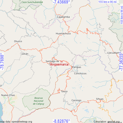
Angasmarca GPS coordinates[2]
8° 7' 59.988" South, 78° 4' 0.012" West
| Map corner | latitude | longitude |
|---|---|---|
| Upper-left | -7.43669°, | -78.7698° |
| Center: | -8.13333°, | -78.06667° |
| Lower-right: | -8.82876°, | -77.36355° |
| Map W x H: | 154.8×154.8 km | = 96.2×96.2mi |
| max Lat: | -0.96667° ⇑26.9% North |
| Angasmarca: | -8.13333° |
| min Lat: | ⇓73.1% South -18.01465° |
| min Long | Angasmarca | max Long |
| -81.30472° | -78.06667° | -69.04167° |
| W 17.6%⇐ | ⇒82.4% E |
Elevation
Elevation of Angasmarca is 2993 m = 9820 ft, and this is 674.3 m = 2212 ft above average elevation for this country.
| Max E: |
5022 m = 16476 ft | 46.2% |
| Angasmarca | 2993 m 9820 ft | |
| Avg. | 2318.7 m = 7607 ft | |
Min E: |
1 m = 3 ft | 53.8% |
See also: Peru elevation on elevation.city.
Geographical zone
Angasmarca is located in South Torrid zone (between Equator and Tropic of Capricorn). Distance of Equator is 904.3 km =561.9 mi to North.| Distance of | km | miles | from Angasmarca |
|---|---|---|---|
| Equator | 904.3 | 561.9 | to North |
| Tropic Capricorn | 1701.6 | 1057.3 | to South |
| Antarctic Circle | 6496.8 | 4036.9 | to South |
| South Pole | 9102.7 | 5656.2 | to South |


Nearby cities:
15 places around Angasmarca: (largest is in red/bold)
• Bolognesi
24.1 km =15 mi,  180°
180°
• Cabana
29.9 km =18.6 mi,  172°
172°
• Conchucos
28.1 km =17.5 mi,  121°
121°
• Curgos
33.3 km =20.7 mi,  24°
24°
• Huacaschuque
19.9 km =12.4 mi,  158°
158°
• Huamachuco
37.1 km =23.1 mi,  0°
0°
• Huandoval
24.1 km =15 mi, 157°
• Lacabamba
23.6 km =14.7 mi,  128°
128°
• Mollepata
14.8 km =9.2 mi, 119°
• Pallasca
14.1 km =8.8 mi, 157°
• Pampas
19.8 km =12.3 mi,  112°
112°
• Quiruvilca
23.6 km =14.7 mi,  321°
321°
• Santiago de Chuco
11.8 km =7.3 mi,  265°
265°
• Sitabamba
38.3 km =23.8 mi,  73°
73°
• Tauca
39 km =24.2 mi, 177°
Sources, notices
• [Note1] Compared only with cities in Peru existing in our database
• [Src1] Map data: © OpenStreetMap contributors (CC-BY-SA)
• [Src2] Other city data from geonames.org with taken over terms of usage.
• [Src3] Geographical zone / Annual Mean Temperature by Robert A. Rohde @ Wikipedia
