Curgos geodata
Curgos (La Libertad) is a seat of a third-order administrative division; located in Peru in America/Lima (GMT-5) time zone. In our database, there are 305 cities with bigger population. Compared to other cities in Peru, 74.6% of cities are located further ↓South; 80.1% of cities are located further →East and 63.5% of cities have lower elevation than Curgos. Note1


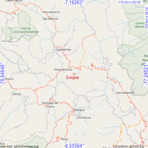
Curgos GPS coordinates[2]
7° 51' 34.992" South, 77° 56' 35.988" West
| Map corner | latitude | longitude |
|---|---|---|
| Upper-left | -7.16263°, | -78.64646° |
| Center: | -7.85972°, | -77.94333° |
| Lower-right: | -8.55564°, | -77.24021° |
| Map W x H: | 154.9×154.9 km | = 96.3×96.3mi |
| max Lat: | -0.96667° ⇑25.4% North |
| Curgos: | -7.85972° |
| min Lat: | ⇓74.6% South -18.01465° |
| min Long | Curgos | max Long |
| -81.30472° | -77.94333° | -69.04167° |
| W 19.9%⇐ | ⇒80.1% E |
Elevation
Elevation of Curgos is 3236 m = 10617 ft, and this is 917.3 m = 3010 ft above average elevation for this country.
| Max E: |
5022 m = 16476 ft | 36.5% |
| Curgos | 3236 m 10617 ft | |
| Avg. | 2318.7 m = 7607 ft | |
Min E: |
1 m = 3 ft | 63.5% |
See also: Peru elevation on elevation.city.
Geographical zone
Curgos is located in South Torrid zone (between Equator and Tropic of Capricorn). Distance of Equator is 873.9 km =543 mi to North.| Distance of | km | miles | from Curgos |
|---|---|---|---|
| Equator | 873.9 | 543 | to North |
| Tropic Capricorn | 1732 | 1076.2 | to South |
| Antarctic Circle | 6527.3 | 4055.9 | to South |
| South Pole | 9133.1 | 5675 | to South |


Nearby cities:
15 places around Curgos: (largest is in red/bold)
• Angasmarca
33.3 km =20.7 mi,  204°
204°
• Aricapampa
25.6 km =15.9 mi,  76°
76°
• Cajabamba
29.5 km =18.3 mi,  336°
336°
• Cauday
34.4 km =21.4 mi,  333°
333°
• Chugay
12 km =7.5 mi,  43°
43°
• Huamachuco
15.1 km =9.4 mi,  296°
296°
• Lluchubamba
37.7 km =23.4 mi,  355°
355°
• Marcabal
20.3 km =12.6 mi, 330°
• Mollepata
37.8 km =23.5 mi,  181°
181°
• Pallasca
44.1 km =27.4 mi,  190°
190°
• Pampas
38.1 km =23.7 mi,  172°
172°
• Quiruvilca
30.7 km =19.1 mi,  247°
247°
• Santiago de Chuco
40.2 km =25 mi,  218°
218°
• Sartimbamba
28.3 km =17.6 mi,  50°
50°
• Sitabamba
30.1 km =18.7 mi,  129°
129°
Sources, notices
• [Note1] Compared only with cities in Peru existing in our database
• [Src1] Map data: © OpenStreetMap contributors (CC-BY-SA)
• [Src2] Other city data from geonames.org with taken over terms of usage.
• [Src3] Geographical zone / Annual Mean Temperature by Robert A. Rohde @ Wikipedia
