Huamachuco geodata
Huamachuco (La Libertad) is a seat of a third-order administrative division; located in Peru in America/Lima (GMT-5) time zone. With population of 21,768 people, there are 80 cities with bigger population in this country. Compared to other cities in Peru, 75.1% of cities are located further ↓South; 82.4% of cities are located further →East and 69.9% of cities have lower elevation than Huamachuco. Note1


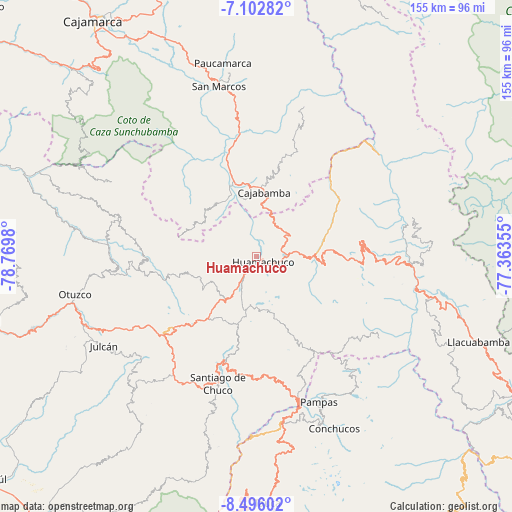
Huamachuco GPS coordinates[2]
7° 48' 0" South, 78° 4' 0.012" West
| Map corner | latitude | longitude |
|---|---|---|
| Upper-left | -7.10282°, | -78.7698° |
| Center: | -7.8°, | -78.06667° |
| Lower-right: | -8.49602°, | -77.36355° |
| Map W x H: | 154.9×154.9 km | = 96.3×96.3mi |
| max Lat: | -0.96667° ⇑24.9% North |
| Huamachuco: | -7.8° |
| min Lat: | ⇓75.1% South -18.01465° |
| min Long | Huamachuco | max Long |
| -81.30472° | -78.06667° | -69.04167° |
| W 17.6%⇐ | ⇒82.4% E |
Elevation
Elevation of Huamachuco is 3341 m = 10961 ft, and this is 1022.3 m = 3354 ft above average elevation for this country.
| Max E: |
5022 m = 16476 ft | 30.1% |
| Huamachuco | 3341 m 10961 ft | |
| Avg. | 2318.7 m = 7607 ft | |
Min E: |
1 m = 3 ft | 69.9% |
See also: Peru elevation on elevation.city.
Geographical zone
Huamachuco is located in South Torrid zone (between Equator and Tropic of Capricorn). Distance of Equator is 867.3 km =538.9 mi to North.| Distance of | km | miles | from Huamachuco |
|---|---|---|---|
| Equator | 867.3 | 538.9 | to North |
| Tropic Capricorn | 1738.6 | 1080.3 | to South |
| Antarctic Circle | 6533.9 | 4060 | to South |
| South Pole | 9139.8 | 5679.2 | to South |


Nearby cities:
15 places around Huamachuco: (largest is in red/bold)
• Angasmarca
37.1 km =23.1 mi,  180°
180°
• Aricapampa
38.5 km =23.9 mi,  90°
90°
• Cajabamba
20.5 km =12.7 mi,  5°
5°
• Cauday
24.2 km =15 mi,  355°
355°
• Charat
42.4 km =26.3 mi,  264°
264°
• Chugay
21.9 km =13.6 mi,  84°
84°
• Curgos
15.1 km =9.4 mi,  116°
116°
• Huaranchal
44.2 km =27.5 mi,  287°
287°
• La Grama
37.8 km =23.5 mi,  348°
348°
• Lluchubamba
32.7 km =20.3 mi,  18°
18°
• Marcabal
11.7 km =7.3 mi, 18°
• Quiruvilca
23.6 km =14.7 mi,  218°
218°
• Santiago de Chuco
39.7 km =24.7 mi,  197°
197°
• Sartimbamba
37.3 km =23.2 mi,  72°
72°
• Usquil
38.6 km =24 mi,  267°
267°
Sources, notices
• [Note1] Compared only with cities in Peru existing in our database
• [Src1] Map data: © OpenStreetMap contributors (CC-BY-SA)
• [Src2] Other city data from geonames.org with taken over terms of usage.
• [Src3] Geographical zone / Annual Mean Temperature by Robert A. Rohde @ Wikipedia
