Yanacancha geodata
Yanacancha (Junin) is a seat of a third-order administrative division; located in Peru in America/Lima (GMT-5) time zone. In our database, there are 305 cities with bigger population. Compared to other cities in Peru, 55.3% of cities are located further ↑North; 53.6% of cities are located further ←West and 93.9% of cities have lower elevation than Yanacancha. Note1


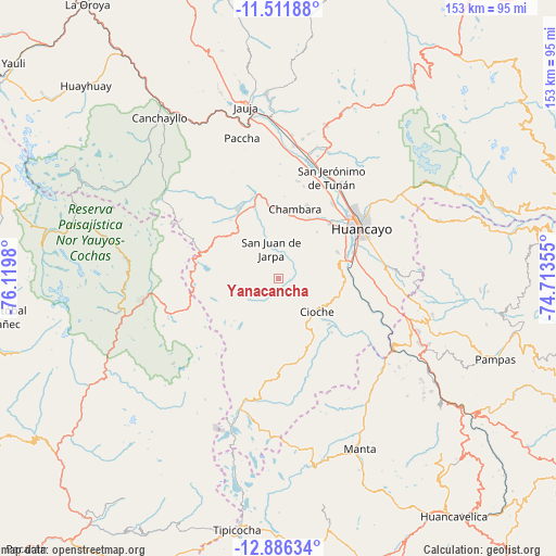
Yanacancha GPS coordinates[2]
12° 12' 0" South, 75° 25' 0.012" West
| Map corner | latitude | longitude |
|---|---|---|
| Upper-left | -11.51188°, | -76.1198° |
| Center: | -12.2°, | -75.41667° |
| Lower-right: | -12.88634°, | -74.71355° |
| Map W x H: | 152.8×152.8 km | = 94.9×94.9mi |
| max Lat: | -0.96667° ⇑55.3% North |
| Yanacancha: | -12.2° |
| min Lat: | ⇓44.7% South -18.01465° |
| min Long | Yanacancha | max Long |
| -81.30472° | -75.41667° | -69.04167° |
| W 53.6%⇐ | ⇒46.4% E |
Elevation
Elevation of Yanacancha is 3967 m = 13015 ft, and this is 1648.3 m = 5408 ft above average elevation for this country.
| Max E: |
5022 m = 16476 ft | 6.1% |
| Yanacancha | 3967 m 13015 ft | |
| Avg. | 2318.7 m = 7607 ft | |
Min E: |
1 m = 3 ft | 93.9% |
See also: Peru elevation on elevation.city.
Geographical zone
Yanacancha is located in South Torrid zone (between Equator and Tropic of Capricorn). Distance of this Southern Tropic circle is 1249.4 km =776.3 mi to South.| Distance of | km | miles | from Yanacancha |
|---|---|---|---|
| Equator | 1356.5 | 842.9 | to North |
| Tropic Capricorn | 1249.4 | 776.3 | to South |
| Antarctic Circle | 6044.7 | 3756 | to South |
| South Pole | 8650.5 | 5375.2 | to South |


Nearby cities:
15 places around Yanacancha: (largest is in red/bold)
• Aco
27.5 km =17.1 mi,  10°
10°
• Ahuac
16.5 km =10.3 mi,  26°
26°
• Chacapampa
24.6 km =15.3 mi,  132°
132°
• Chambara
20.7 km =12.9 mi, 10°
• Chicche
18.3 km =11.4 mi, 127°
• Chupaca
20.7 km =12.9 mi,  44°
44°
• Colca
24.4 km =15.2 mi,  117°
117°
• Cullhuas
27.4 km =17 mi,  97°
97°
• El Tambo
26.3 km =16.3 mi,  55°
55°
• Huacrapuquio
21.8 km =13.5 mi,  85°
85°
• Huayucachi
21.3 km =13.2 mi,  69°
69°
• Jarpa
10.7 km =6.6 mi,  329°
329°
• Pilcomay
24.9 km =15.5 mi,  46°
46°
• Sapallanga
26 km =16.2 mi,  77°
77°
• Sicaya
23.5 km =14.6 mi, 38°
Sources, notices
• [Note1] Compared only with cities in Peru existing in our database
• [Src1] Map data: © OpenStreetMap contributors (CC-BY-SA)
• [Src2] Other city data from geonames.org with taken over terms of usage.
• [Src3] Geographical zone / Annual Mean Temperature by Robert A. Rohde @ Wikipedia
