Chupaca geodata
Chupaca (Junin) is a seat of a third-order administrative division; located in Peru in America/Lima (GMT-5) time zone. With population of 9,877 people, there are 143 cities with bigger population in this country. Compared to other cities in Peru, 54% of cities are located further ↑North; 55.5% of cities are located further ←West and 64.8% of cities have lower elevation than Chupaca. Note1


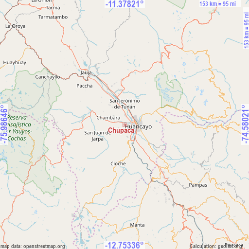
Chupaca GPS coordinates[2]
12° 4' 0.012" South, 75° 16' 59.988" West
| Map corner | latitude | longitude |
|---|---|---|
| Upper-left | -11.37821°, | -75.98646° |
| Center: | -12.06667°, | -75.28333° |
| Lower-right: | -12.75336°, | -74.58021° |
| Map W x H: | 152.9×152.9 km | = 95×95mi |
| max Lat: | -0.96667° ⇑54% North |
| Chupaca: | -12.06667° |
| min Lat: | ⇓46% South -18.01465° |
| min Long | Chupaca | max Long |
| -81.30472° | -75.28333° | -69.04167° |
| W 55.5%⇐ | ⇒44.5% E |
Elevation
Elevation of Chupaca is 3254 m = 10676 ft, and this is 935.3 m = 3069 ft above average elevation for this country.
| Max E: |
5022 m = 16476 ft | 35.2% |
| Chupaca | 3254 m 10676 ft | |
| Avg. | 2318.7 m = 7607 ft | |
Min E: |
1 m = 3 ft | 64.8% |
See also: Peru elevation on elevation.city.
Geographical zone
Chupaca is located in South Torrid zone (between Equator and Tropic of Capricorn). Distance of this Southern Tropic circle is 1264.2 km =785.5 mi to South.| Distance of | km | miles | from Chupaca |
|---|---|---|---|
| Equator | 1341.7 | 833.7 | to North |
| Tropic Capricorn | 1264.2 | 785.5 | to South |
| Antarctic Circle | 6059.5 | 3765.2 | to South |
| South Pole | 8665.4 | 5384.4 | to South |


Nearby cities:
15 places around Chupaca: (largest is in red/bold)
• Ahuac
7.2 km =4.5 mi,  270°
270°
• Chambara
12.2 km =7.6 mi,  297°
297°
• El Tambo
7.2 km =4.5 mi,  90°
90°
• Huacrapuquio
14.9 km =9.3 mi,  150°
150°
• Hualhuas
11.2 km =7 mi,  18°
18°
• Huancayo
8.5 km =5.3 mi, 88°
• Huayucachi
9.2 km =5.7 mi,  143°
143°
• Orcotuna
11.2 km =7 mi,  346°
346°
• Pilcomay
4.3 km =2.7 mi,  59°
59°
• Quilcas
14.8 km =9.2 mi,  10°
10°
• San Agustin
11 km =6.8 mi, 15°
• San Jerónimo
12.3 km =7.6 mi,  359°
359°
• Sapallanga
14.3 km =8.9 mi,  130°
130°
• Saño
12.6 km =7.8 mi, 13°
• Sicaya
3.7 km =2.3 mi,  0°
0°
Sources, notices
• [Note1] Compared only with cities in Peru existing in our database
• [Src1] Map data: © OpenStreetMap contributors (CC-BY-SA)
• [Src2] Other city data from geonames.org with taken over terms of usage.
• [Src3] Geographical zone / Annual Mean Temperature by Robert A. Rohde @ Wikipedia
