Surcubamba geodata
Surcubamba (Huancavelica) is a seat of a third-order administrative division; located in Peru in America/Lima (GMT-5) time zone. In our database, there are 305 cities with bigger population. Compared to other cities in Peru, 54.8% of cities are located further ↑North; 60.8% of cities are located further ←West and 63.5% of cities have higher elevation than Surcubamba. Note1
Administrative division(s):
- Level 1: Huancavelica
- Level 2: Provincia de Tayacaja
- Level 3: Surcubamba


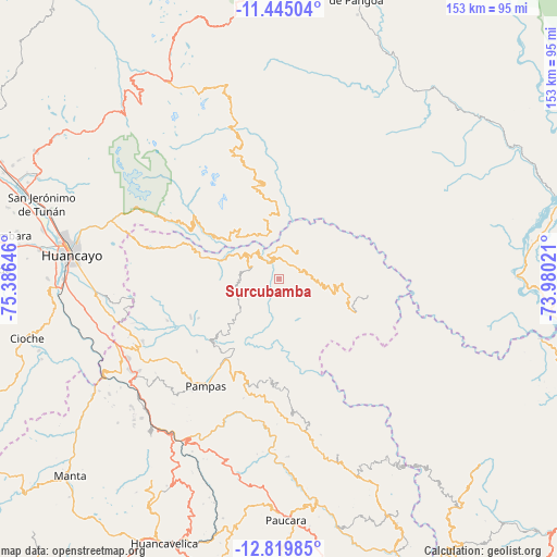
Surcubamba GPS coordinates[2]
12° 7' 59.988" South, 74° 40' 59.988" West
| Map corner | latitude | longitude |
|---|---|---|
| Upper-left | -11.44504°, | -75.38646° |
| Center: | -12.13333°, | -74.68333° |
| Lower-right: | -12.81985°, | -73.98021° |
| Map W x H: | 152.9×152.9 km | = 95×95mi |
| max Lat: | -0.96667° ⇑54.8% North |
| Surcubamba: | -12.13333° |
| min Lat: | ⇓45.2% South -18.01465° |
| min Long | Surcubamba | max Long |
| -81.30472° | -74.68333° | -69.04167° |
| W 60.8%⇐ | ⇒39.2% E |
Elevation
Elevation of Surcubamba is 2195 m = 7201 ft, and this is 123.7 m = 406 ft below average elevation for this country.
| Max E: |
5022 m = 16476 ft | 63.5% |
| Avg. | 2318.7 m = 7607 ft | |
| Surcubamba | 2195 m = 7201 ft | |
Min E: |
1 m = 3 ft | 36.5% |
See also: Peru elevation on elevation.city.
Geographical zone
Surcubamba is located in South Torrid zone (between Equator and Tropic of Capricorn). Distance of this Southern Tropic circle is 1256.8 km =780.9 mi to South.| Distance of | km | miles | from Surcubamba |
|---|---|---|---|
| Equator | 1349.1 | 838.3 | to North |
| Tropic Capricorn | 1256.8 | 780.9 | to South |
| Antarctic Circle | 6052.1 | 3760.6 | to South |
| South Pole | 8658 | 5379.8 | to South |


Nearby cities:
15 places around Surcubamba: (largest is in red/bold)
• Acoria
58 km =36 mi,  202°
202°
• Andamarca
46.5 km =28.9 mi,  343°
343°
• Colcabamba
29.7 km =18.5 mi,  183°
183°
• Cuenca
50.6 km =31.4 mi,  228°
228°
• Cullhuas
53.7 km =33.4 mi,  258°
258°
• Huancayo
57.2 km =35.5 mi,  277°
277°
• Huaribamba
32.6 km =20.3 mi,  242°
242°
• Izcuchaca
53.2 km =33.1 mi,  222°
222°
• La Esmeralda
56.3 km =35 mi,  170°
170°
• Pampas
35.3 km =21.9 mi,  214°
214°
• Paucarbamba
48.5 km =30.1 mi,  162°
162°
• Pazos
47.6 km =29.6 mi,  251°
251°
• Pilchaca
54.1 km =33.6 mi, 236°
• Salcabamba
13.2 km =8.2 mi, 235°
• Sapallanga
54.4 km =33.8 mi,  268°
268°
Sources, notices
• [Note1] Compared only with cities in Peru existing in our database
• [Src1] Map data: © OpenStreetMap contributors (CC-BY-SA)
• [Src2] Other city data from geonames.org with taken over terms of usage.
• [Src3] Geographical zone / Annual Mean Temperature by Robert A. Rohde @ Wikipedia
