San Agustin geodata
San Agustin (Junin) is a seat of a third-order administrative division; located in Peru in America/Lima (GMT-5) time zone. With population of 5,998 people, there are 207 cities with bigger population in this country. Compared to other cities in Peru, 53% of cities are located further ↑North; 56.1% of cities are located further ←West and 64.9% of cities have lower elevation than San Agustin. Note1


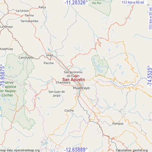
San Agustin GPS coordinates[2]
11° 58' 19.02" South, 75° 15' 20.232" West
| Map corner | latitude | longitude |
|---|---|---|
| Upper-left | -11.28326°, | -75.95875° |
| Center: | -11.97195°, | -75.25562° |
| Lower-right: | -12.65889°, | -74.5525° |
| Map W x H: | 153×153 km | = 95.1×95.1mi |
| max Lat: | -0.96667° ⇑53% North |
| San Agustin: | -11.97195° |
| min Lat: | ⇓47% South -18.01465° |
| min Long | San Agustin | max Long |
| -81.30472° | -75.25562° | -69.04167° |
| W 56.1%⇐ | ⇒43.9% E |
Elevation
Elevation of San Agustin is 3257 m = 10686 ft, and this is 938.3 m = 3078 ft above average elevation for this country.
| Max E: |
5022 m = 16476 ft | 35.1% |
| San Agustin | 3257 m 10686 ft | |
| Avg. | 2318.7 m = 7607 ft | |
Min E: |
1 m = 3 ft | 64.9% |
See also: Peru elevation on elevation.city.
Geographical zone
San Agustin is located in South Torrid zone (between Equator and Tropic of Capricorn). Distance of this Southern Tropic circle is 1274.8 km =792.1 mi to South.| Distance of | km | miles | from San Agustin |
|---|---|---|---|
| Equator | 1331.2 | 827.2 | to North |
| Tropic Capricorn | 1274.8 | 792.1 | to South |
| Antarctic Circle | 6070 | 3771.7 | to South |
| South Pole | 8675.9 | 5391 | to South |


Nearby cities:
15 places around San Agustin: (largest is in red/bold)
• Aco
12.5 km =7.8 mi,  277°
277°
• Chupaca
11 km =6.8 mi,  195°
195°
• Concepción
8.8 km =5.5 mi,  313°
313°
• El Tambo
11.4 km =7.1 mi,  158°
158°
• Hualhuas
0.5 km =0.3 mi,  84°
84°
• Huancayo
11.7 km =7.3 mi,  151°
151°
• Ingenio
9.2 km =5.7 mi,  353°
353°
• Matahuasi
13.1 km =8.1 mi, 313°
• Orcotuna
5.7 km =3.5 mi,  273°
273°
• Pilcomay
8.4 km =5.2 mi,  175°
175°
• Quichuay
9.7 km =6 mi,  340°
340°
• Quilcas
4 km =2.5 mi, 353°
• San Jerónimo
3.6 km =2.2 mi,  299°
299°
• Saño
1.7 km =1.1 mi,  355°
355°
• Sicaya
7.5 km =4.7 mi, 203°
Sources, notices
• [Note1] Compared only with cities in Peru existing in our database
• [Src1] Map data: © OpenStreetMap contributors (CC-BY-SA)
• [Src2] Other city data from geonames.org with taken over terms of usage.
• [Src3] Geographical zone / Annual Mean Temperature by Robert A. Rohde @ Wikipedia
