Orcotuna geodata
Orcotuna (Junin) is a populated place; located in Peru in America/Lima (GMT-5) time zone. With population of 4,199 people, there are 263 cities with bigger population in this country. Compared to other cities in Peru, 52.9% of cities are located further ↑North; 55.1% of cities are located further ←West and 64.4% of cities have lower elevation than Orcotuna. Note1


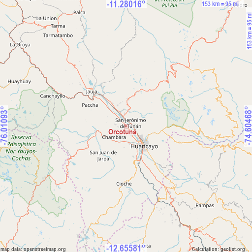
Orcotuna GPS coordinates[2]
11° 58' 7.896" South, 75° 18' 28.08" West
| Map corner | latitude | longitude |
|---|---|---|
| Upper-left | -11.28016°, | -76.01093° |
| Center: | -11.96886°, | -75.3078° |
| Lower-right: | -12.65581°, | -74.60468° |
| Map W x H: | 153×153 km | = 95.1×95.1mi |
| max Lat: | -0.96667° ⇑52.9% North |
| Orcotuna: | -11.96886° |
| min Lat: | ⇓47.1% South -18.01465° |
| min Long | Orcotuna | max Long |
| -81.30472° | -75.3078° | -69.04167° |
| W 55.1%⇐ | ⇒44.9% E |
Elevation
Elevation of Orcotuna is 3250 m = 10663 ft, and this is 931.3 m = 3055 ft above average elevation for this country.
| Max E: |
5022 m = 16476 ft | 35.6% |
| Orcotuna | 3250 m 10663 ft | |
| Avg. | 2318.7 m = 7607 ft | |
Min E: |
1 m = 3 ft | 64.4% |
See also: Peru elevation on elevation.city.
Geographical zone
Orcotuna is located in South Torrid zone (between Equator and Tropic of Capricorn). Distance of this Southern Tropic circle is 1275.1 km =792.3 mi to South.| Distance of | km | miles | from Orcotuna |
|---|---|---|---|
| Equator | 1330.8 | 826.9 | to North |
| Tropic Capricorn | 1275.1 | 792.3 | to South |
| Antarctic Circle | 6070.4 | 3772 | to South |
| South Pole | 8676.2 | 5391.1 | to South |


Nearby cities:
15 places around Orcotuna: (largest is in red/bold)
• Aco
6.9 km =4.3 mi,  280°
280°
• Ahuac
11.8 km =7.3 mi,  202°
202°
• Chambara
9.8 km =6.1 mi,  237°
237°
• Chupaca
11.2 km =7 mi,  166°
166°
• Concepción
5.7 km =3.5 mi,  353°
353°
• Hualhuas
6.2 km =3.9 mi,  92°
92°
• Ingenio
9.9 km =6.2 mi,  27°
27°
• Matahuasi
9.4 km =5.8 mi,  335°
335°
• Pilcomay
10.8 km =6.7 mi,  143°
143°
• Quichuay
9.1 km =5.7 mi,  15°
15°
• Quilcas
6.4 km =4 mi,  54°
54°
• San Agustin
5.7 km =3.5 mi, 93°
• San Jerónimo
3 km =1.9 mi,  60°
60°
• Saño
5.7 km =3.5 mi,  76°
76°
• Sicaya
7.6 km =4.7 mi,  159°
159°
Sources, notices
• [Note1] Compared only with cities in Peru existing in our database
• [Src1] Map data: © OpenStreetMap contributors (CC-BY-SA)
• [Src2] Other city data from geonames.org with taken over terms of usage.
• [Src3] Geographical zone / Annual Mean Temperature by Robert A. Rohde @ Wikipedia
